

Much of the state’s water supply originates in forested headwaters high in the mountains. Yufang Jin is a UC Davis professor specializing in ecosystem change and remote sensing (gathering aerial images of the earth). She is also a member of the PPIC Water Policy Center’s research network. She talked to us about how a warming climate and extreme wildfires are changing these crucial ecosystems.
 PPIC: How are large wildfires changing our watersheds?
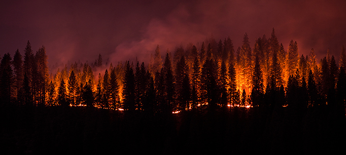
Yufang Jin: We’re seeing intensifying wildfires in California, especially in the headwater regions where our rivers originate. More intense fires have significantly changed the composition and structure of forest ecosystems, affecting both water quality and quantity—though not always for the worse. For example, large fires can significantly reduce the amount of vegetation covering the land, which reduces the amount of water consumed by plants. Burned areas also have much less water circulating in the soil. Both of these post-fire processes have a positive impact on streamflow, as more water works its way into the water table and streams. But the loss of groundcover plants from intense fires also increases surface erosion, which can cause landslides in the rainy season. Ashes and sediments flowing into streams harm water quality.
PPIC: What are catastrophic fires teaching us about managing forests, wildfires, and water in California?
YJ: They’re pushing us to use management strategies that recognize the relationships between forests, fires, and water supply. In the past most forest management focused on wildfire suppression. There’s now recognition that solely focusing on suppression led to unnaturally dense forests, which in turn led to larger and catastrophic fires. So now there’s a growing effort to use forest thinning and prescribed fires to reduce fire hazards. Some pilot projects indicate that allowing natural fire to thin forests can lead to increases in water quantity in the watershed as well. A lot of federal and state agencies are now emphasizing watershed restoration strategies that bring multiple benefits. They are paying more attention to approaches that reduce fire hazards and may also increase water yields.
PPIC: How will climate change affect the severity of wildfires in California?
YJ: All climate models predict that the warming trend will continue in coming decades, and will often be accompanied by drier conditions. There is consensus that with these conditions, we can expect more severe wildfires across California and in the West more generally. One of our recent studies showed that the average area burned in Southern California could increase 70 percent by mid-century. Another effect of climate change is that forests in the western US will become more vulnerable to drought stress, making them more prone to diseases and beetles, leading to greater tree mortality and more fires.
PPIC: What kinds of technological advances can help us improve watershed management in the state?
YJ: There are two technologies that can provide more informed water management. One is obtaining images from satellites with remote sensors to learn about ecological and hydrological conditions on the ground. The other is using big data analytics and cloud computing, which can help us interpret the huge amount of data you get from remote sensors and translate it into information that farmers and water managers can use and act upon.
Basically, remote sensors can be used to monitor factors like water temperatures, the range of particular plant types, or the amount of water being released from plants. You can observe relatively large areas over time in a cost-effective way. For example, remote sensors can help detect algal blooms and invasive aquatic species throughout the watershed. Water managers can use remote sensing to estimate how much water is being used by crops or by natural vegetation, and how that water use changes from season to season or year to year. It can also help figure out how ecosystems will respond to a changing climate or how changing land use can affect water use. For fire management, remote sensing can track when and where fires occur, how effective fuel treatment projects are in reducing fire severity, and how vegetation recovers after fires.
While there are no simple technological solutions for managing the effect of a changing climate, having tools like these will make it much easier to get the quantitative information that we need to develop adaptive forest and watershed management strategies.
Read California’s Water: Protecting Headwaters (from California’s Water briefing kit, October 2016)
Read “Managing Wildfires Requires New Strategies” (PPIC Blog, September 23, 2015)
Visit the PPIC Water Policy Center’s drought resource page