

The decennial census plays an essential role in American democracy. The stakes are huge for California, and 2020 is fast approaching. This series of blog posts takes a detailed look at California communities that may be at risk of being undercounted.
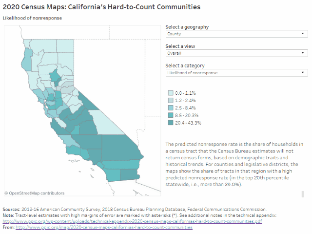
PPIC’s interactive census maps are an important tool for Californians working to ensure an accurate census count. Using estimates from the Census Bureau and the Federal Communications Commission, they highlight hard-to-count communities across the state and pinpoint reasons why certain areas may be hard to reach.
The Inland Empire is home to more than 4.5 million Californians (over 11% of the state’s population). About 29% of census tracts in San Bernardino County are likely to be very hard to count, compared to 17% in Riverside County, according to Census Bureau estimates that draw on demographic characteristics and historical trends. Households in these very hard-to-count areas are less likely to respond initially to census forms and are therefore at risk of being undercounted. Many hard-to-reach census tracts are clustered in and around the San Bernardino–Riverside metro area, including the neighboring cities of Moreno Valley and Ontario.
Some highlights:
- Very hard-to-count communities in the Inland Empire tend to be concentrated in urban legislative districts. Since legislative district lines will be redrawn based on the census, disproportionately undercounting parts of the Inland Empire could affect the region’s political representation. For example, in Congressional Districts 31 (Aguilar) and 35 (Torres), more than 30% of census tracts are likely to be very hard to count. The same is true for State Senate District 20 (Leyva) and State Assembly Districts 40 (Steinorth), 47 (Reyes), and 52 (Rodriguez).
- Undercounting people of color could disproportionately affect the Inland Empire. African Americans, Latinos, and Native Americans tend to be undercounted in the census. These groups make up more than half of the population in the Inland Empire—54% in Riverside County and 60% in San Bernardino County—compared to 45% statewide. In metro areas, over 80% of residents in many neighborhoods are people of color. The Inland Empire also includes several tribal reservations, such as those southeast of Coachella and northwest of Palm Springs.
- Parts of the Inland Empire have particularly high shares of young children. Young children are historically underrepresented in the census. Riverside and San Bernardino Counties have relatively high percentages of young children (6.8% and 7.3%, respectively) compared to the state as a whole (6.5%). Certain areas have even higher concentrations of families with young children: children under five years old make up between 9% and 11% of the population around Victorville, in western San Bernardino County, and the same is true for numerous census tracts around the city of San Bernardino.
- Communities can be hard to count for multiple reasons. Housing conditions (high shares of rentals, overcrowded rental units, and mobile homes) may make it more difficult to count residents accurately. There is hard-to-count housing throughout the Inland Empire, with pockets in metro areas, south of Moreno Valley, and in the rural eastern parts of the region. Residents may also be hard to count for other reasons. For example, in some areas with hard-to-count housing, many residents are noncitizens—who may be less likely to respond in 2020 due to the planned addition of a citizenship question. Recognizing ways that hard-to-count communities intersect with each other will be critical to conducting effective outreach to Inland Empire residents.
- Rural areas tend to have lower internet access, as do some urban neighborhoods. The US Census Bureau plans to collect the majority of responses online in 2020—a change from previous practice. The eastern, rural parts of the Inland Empire have low levels of residential high-speed internet access and therefore may face more challenges responding to the census online. We also see lower levels of access in the city of San Bernardino and Moreno Valley relative to surrounding areas. It’s important to note that people may still have internet access through smartphones, public libraries, or other services.
We hope these maps serve as a starting point to help local, regional, and state leaders think about which activities, resources, and partnerships—including language assistance, awareness raising, and community outreach—might be most effective for accurately counting different parts of California. Stay tuned for future posts that examine hard-to-count communities in other regions of the state.