Groundwater recharge is a key part of securing California’s water supply. But how do we ensure our efforts to store more water underground will work? Stanford’s Rosemary Knight shares new research that could help the state recharge its aquifers faster and more efficiently.
Tell us about your project. What problem is it trying to solve, and how?
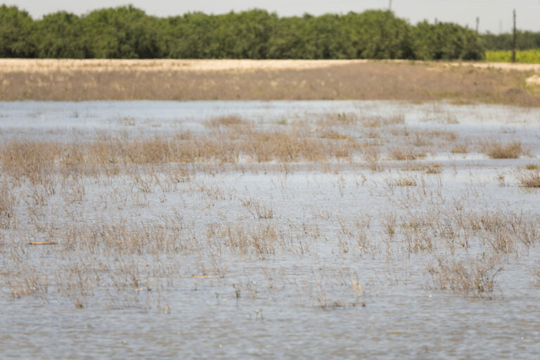
In California, our groundwater system is out of balance. More water is going out than is coming in, which is causing a host of problems—falling water levels, domestic wells going dry, land subsidence, ecosystems under stress, and water quality problems. There’s a lot of space in the aquifers after all the groundwater pumping, and natural recharge isn’t filling it adequately. We could supplement with managed aquifer recharge (MAR). That means sending the excess water in wet years to locations where it can move downward and replenish our groundwater systems. Spreading water in a dedicated recharge basin, agricultural field, or floodplain could move it efficiently down below the surface, depending on the geologic characteristics of the site.
There is currently a lot of enthusiasm for MAR. But where are the optimal locations?
Here’s the problem: not all potential recharge sites are created equal. Growers are concerned about this, and for good reason. The type of sediment—coarse-grained material like sand or gravel, or fine-grained clay—determines whether water moves down into an aquifer or ponds at the surface. When water ponds, it can be lost to evaporation. Worse, if a grower floods a field—say an almond grove—and the water ponds, it could weaken roots, destabilize the trees, and cause disease. An entire orchard could be ruined.
UC Davis has a recharge map that assesses a site’s viability, but it only focuses on sediment type in the top meter. You can get down two meters and hit clay, and the recharge water will just sit there. Given the risks, people need more robust data.
We want to accurately assess locations to host MAR facilities. We’re looking for what we call “fastpaths”: interconnected pathways of coarse-grained sediments like sand and gravel that can quickly move water from the surface down to the water table. That land could be designated and ideally even zoned for recharge. We use the data acquired with an airborne electromagnetic (AEM) system to see the sediment type to depths of 300 meters. We combine the AEM data with a ground-based geophysical system to get higher resolution information in the top 80 meters.
How did these improvements in geologic data come about?
First, the Stanford Environmental Geophysics Research Group partnered with Aqua Geo Frameworks to conduct a pilot study to demonstrate the value of AEM data for groundwater management in the Central Valley. We then spent two years leading a study that brought together academic and private sector researchers and practitioners with state and local water agencies to figure out how best to conduct a statewide AEM survey. A key part of that study was determining how to integrate well data with the AEM data. The Department of Water Resources then acquired AEM data for all the priority groundwater basins in California.
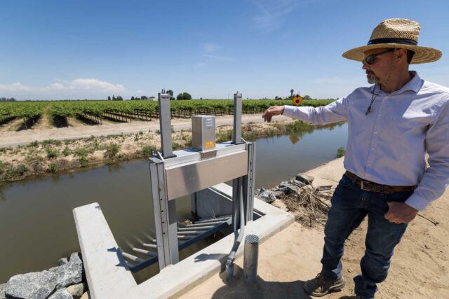
In addition, we also conducted a pilot study with Tulare Irrigation District’s general manager, Aaron Fukuda, to see if a ground-based system developed in Denmark called tTEM would help assess almond orchards, fields, and other small-scale sites. It does. You can drive between tree rows for a closer look, with better subsurface spatial resolution and obtain images of the sediment type. Now we had two types of data to combine.
How do you integrate these data types so growers and water managers can make decisions?
We had an exceptionally talented geophysicist in our Environmental Geophysics Group, Seogi Kang, who wrote the many lines of code that turned all the AEM data in the Central Valley into maps showing the suitability of areas for recharge. An analysis on this scale had never been done before. We developed an algorithm that searches for connected pathways of sand and gravel from a surface location, where recharge water could be released, to the water table. It identifies the most direct pathways, which we call fastpaths. We created a website, so the web-based software and all the results are publicly available.
With this method of analysis, it’s important to work with end users on critical decision points. The level of risk-aversion in terms of ponding is a key factor. What mix of sediment type defines a fastpath—does it need to be 100% sand and gravel or can clay be present? The AEM data still only provide a high-level look. Regardless, before adopting a site for recharge, they’ll need to do a site-specific smaller-scale assessment using tTEM.
It’s important to note that adversely affecting water quality can be a concern when planning for recharge. Our current analysis focuses exclusively on the types of sediments that are present and does not provide information about water quality.
Where do we go from here?
I’m most excited about how these data can inform land use decisions. We need to accelerate groundwater recharge, making use of every wet period. That means investing in identifying and utilizing the best places for recharge as soon as possible. Our work has shown that there are many natural recharge pathways. The phenomenal statewide AEM data set can help us find fastpaths and better value the land that allows us to replenish and sustain our groundwater systems. This could be the starting point for zoning for recharge.
Topics
agriculture groundwater groundwater sustainability San Joaquin Valley SGMA Water Supply Water, Land & AirLearn More
How to Protect Ecosystems That Need Groundwater

Making Recharge a “Win-Win” for Landowners and Groundwater Agencies
How to Set Up Groundwater Agencies for Recharge Success
