Table of Contents
- Key Takeaways
- Introduction
- Bolstering Groundwater Recharge in California
- The Critical Role of the Sacramento–San Joaquin Delta
- Capturing More Water for Recharge in Wet Years
- Implications for Policy and Practice
- Conclusion
- Notes and References
- Authors and Acknowledgments
- PPIC Board of Directors
- Water Policy Center Advisory Council
- Copyright
Key Takeaways
Groundwater recharge is a powerful tool for increasing water supplies and building resilience for dry years. The wet winter of 2023 created ample opportunity for refining and improving recharge practices, and good progress was made—about a 17 percent increase in recharge volumes over 2017, another wet year. But many groundwater basins remain far from their recharge goals, and since 2023, discussion has intensified on how to augment recharge without harming other water users or the environment. Our high-level look at conditions in 2023 in the Central Valley—California’s largest watershed—illustrates how much water would be needed to comply with environmental regulations in the Sacramento–San Joaquin Delta and how much might have been made available for other purposes, including groundwater recharge. Rechargers lack the capacity to capture all of this potentially available water, and some recharge would entail tradeoffs with downstream uses—particularly exports from the south Delta by the state and federal water projects. Still, the abundance of wet years could be better managed by understanding when additional diversions for recharge could take place without harming other users, and when partnerships and policy tools could facilitate more recharge. This analysis also provides a starting point for understanding opportunities and constraints in drier years, when the tradeoffs would loom larger.
- The tradeoffs between new upstream diversions and existing Delta exports can be significant. Very high flows—those that create the potential for flooding and can therefore be diverted without a permit—are unlikely to impact downstream uses. But not all high flows meet this criterion, and especially on the San Joaquin River, new diversions could reduce exports.
- Exporters do not always operate at capacity, creating opportunities for recharge. In wet years, some of the water that the main Delta exporters—the State Water Project and Central Valley Project—are legally entitled to use is left in the system due to infrastructure or demand constraints on export pumping. This water could be diverted by upstream partners and recharged to mutual benefit.
- Reducing flood risk will require more flexibility on upstream diversions. Damaging floods can occur upstream even when flows are below flood “action stage” in the Delta—the level at which local agencies prepare for flooding. Upstream diversion protocols that facilitate flood protection are needed, even when these diversions entail tradeoffs with exports.
- Other state and local policies can help make the most of available water. Recharge efforts could benefit from more nuanced regulations that allow excess water to be captured in wet periods when rivers are below flood stage. Other major hurdles include the cumbersome permitting process for building and operating projects. But local incentives and recharge-crediting systems are beginning to unlock more recharge on privately owned working lands—an area with significant potential for storing more water.
Introduction
Historical reliance on groundwater has resulted in the severe depletion of many of California’s aquifers, leading to problems such as well failures, poor groundwater quality, land subsidence, seawater intrusion, ecosystem degradation, and the depletion of neighboring rivers and streams. The Sustainable Groundwater Management Act (SGMA) requires groundwater basins across the state to address the undesirable results of groundwater use and reach sustainability by the early 2040s. Achieving sustainability will require a portfolio of adaptation strategies, including reducing pumping and augmenting water supplies.
Underground aquifers contain a vast amount of natural water storage capacity, and they provide a faster, more cost-effective storage alternative to new surface reservoirs (Escriva-Bou 2019). Yet California’s efforts to bolster recharge have been hampered by infrastructure constraints, cumbersome permitting processes, and a complex set of regulations governing when additional surface water can be diverted and stored. These limitations make it difficult to capture the large surges of water that arrive in fast, flashy storms (see Mount and Gartrell 2025, for example) or during periods of high snowmelt runoff.
In this report we explore how much water is available for recharge in wet years in the Central Valley—California’s largest watershed. Many of the barriers to using more storm flows for recharge relate to the conditions in the complex Sacramento–San Joaquin Delta, which serves as a hub for moving water both within this region and to other parts of the state. Our recent survey found that interest in recharge has surged in recent years in the San Joaquin Valley—the Central Valley’s southern half, where groundwater basins are heavily overdrafted (Peterson, Hanak, and Joaquín Morales 2024). This report builds on our earlier preliminary analysis of water available for recharge in recent wet years. We explain in detail the regulatory constraints and conditions that govern the availability of this water. We highlight the tradeoffs that may occur between increased upstream use and Delta exports, and the types of partnerships and policy advances that may be needed to divert this water in the future. An accompanying dataset provides comparable information for 2017 and 2023.
We focus the discussion on 2023, a year when high flows presented both flood risks and recharge opportunities. Over the past two decades, wet years occurred five times (2006, 2011, 2017, 2019, and 2023). In such years, there is so much water in the system that some additional recharge could occur without causing environmental or downstream tradeoffs, and there are likely also periods where more recharge would be possible if tradeoffs are properly managed. We do not explore the potential for available water from large storms in drier years, which might offer more limited opportunities for recharge; nor do we consider the smaller recharge opportunities that may arise in some places from using alternative water sources such as agricultural runoff or wastewater. These situations are ripe for further analysis, given their potential for extending the active season for recharge and for enabling incremental progress even in years that are not classified as wet.
Bolstering Groundwater Recharge in California
Recharging more water from large winter and spring storms into California’s underground aquifers is a powerful tool for reducing groundwater overdraft, improving drought preparedness, and limiting flood risk to downstream communities. Putting water into the ground can bolster groundwater storage and mitigate some of the negative impacts of aquifer depletion, including well failures. Especially in a changing climate—where more precipitation is expected to fall in the form of heavy rainstorms (Mount, Sencan, and Dettinger 2023) and snowpack will be reduced—recharge can help support a nimbler water storage system, diverting water away from communities that are in harm’s way while storing water for later use. Recharge projects can provide habitat benefits as well.
We have written extensively about groundwater recharge in recent publications (see Hanak et al. 2018; Escriva-Bou, Sencan, and Hanak 2021; Peterson, Hanak, and Joaquín Morales 2024; and Hanak, Gartrell, and Cole 2024). Here we give an overview of how recharge works, and how it has been growing in the San Joaquin Valley in the years since the adoption of SGMA.
The Nuts and Bolts of Groundwater Recharge
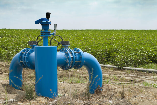
Groundwater recharge is the process by which water refills underground aquifers. While groundwater recharge occurs naturally as water moves across the landscape—sometimes referred to as passive recharge—aquifers can also be refilled through active management. Active recharge usually involves directing water to places suitable for percolation, including unlined canal systems, floodplains, dedicated basins, or farmland. Active recharge has been an integral part of many water systems in Southern California and the Central Valley for decades (Hanak et al. 2011). In recent years, capturing excess water for recharge has gained new traction as part of efforts to meet the requirements of SGMA. As local agencies look to bring their groundwater accounts into balance by reducing demand and augmenting supplies, many point to recharge as an important supply-side tool (Hanak et al. 2020; Cole, Greenspan, and Ayres 2023).
Efforts to bolster recharge are typically most effective when a surplus of water is available that exceeds current demands for agricultural, urban, and environmental uses over an extended period. On average, these wet conditions occur about once every three or four years in California, though large pulses of water with recharge potential can also pass through the system in drier years.
What Legal Parameters Govern Groundwater Recharge?
While seen as an important tool for adapting to a changing climate and improving efficiency in storing water, groundwater recharge—like reservoir storage—is not in and of itself considered a “beneficial use” of water. Beneficial uses of water are defined by the State Water Resources Control Board (State Water Board) and encompass a wide range of uses that achieve the maximum benefit to the people of the state, such as residential and commercial uses, crop irrigation, livestock watering, recreation, tribal uses, and support for fish and wildlife. Only beneficial uses can be considered for new water rights permits. However, by identifying one or more future beneficial uses for recharged water, users can apply for permits to divert and recharge water for these intended purposes.
Temporary permits for groundwater recharge
Obtaining a standard water-right permit is a lengthy process. In addition to meeting environmental standards and complying with other policies, applicants must demonstrate that they have considered prior right holders, and that sufficient unappropriated water is available in their basin. As an alternative approach, several policy reforms over the past decade have responded to the growing interest in recharge by making temporary permits available. In November 2015, Governor Jerry Brown issued Executive Order B-36-15, which directs the State Water Board to create an expedited process allowing diverters to apply for temporary, 180-day permits to access water for groundwater recharge during high-flow conditions. Since then, 42 such permits have been issued, authorizing just under 1.5 million acre-feet (maf) of diversions—though only about 53,000 acre-feet (af) have actually been diverted. In 2019, the state legislature passed AB 658, which authorizes the State Water Board to issue temporary permits for the diversion of surface water to underground storage. That year the board introduced five-year temporary permits and a streamlined process for obtaining them (SWRCB 2019). To date, only two such permits have been issued, with 755 af diverted. Holders of temporary permits of either duration have rights to the subsequent use of the water that they are authorized to store under the permit.
Although streamlined permits are only applicable for projects that divert high flows during wet months (December 1 through March 31), the laws and regulations that apply to the standard water right permitting process also apply to the streamlined process. In particular, would-be diverters must demonstrate adequate water availability. The streamlining process allows them to do so following one of two simplified methods: 1) by using the “90th percentile/20 percent” method, otherwise known as the “90/20” rule, or 2) by documenting threat of imminent flood conditions. The 90/20 rule requires that daily streamflow at a specified diversion point is above the 90th percentile, and that diversion amounts are subsequently limited to 20 percent of the daily flow. If applicants for temporary permits do not use these simplified standards, they must conduct a full “water availability analysis” to demonstrate that the diversion will not harm other water right holders or the environment, that the applicant has an urgent need for the water to be diverted, and that such a diversion would be in the public interest.
Unpermitted authorizations to divert flood flows
In spring 2023, towards the end of an intense winter storm season, Governor Gavin Newsom signed Executive Orders N-4-23, N-6-23, and N-7-23, aimed at further expediting recharge efforts during flood conditions. These executive orders (EOs) suspended permitting requirements for floodwater diversions and California Environmental Quality Act (CEQA) requirements for emergency flood preparedness and response. Later in 2023, parts of these EOs were codified into law via SB 122, which modified language in the State Water Code (section 1242.1–3). Most recently, in late January of 2025 the governor issued Executive Order N-16-25, which waived SB 122’s requirement that flood threshold definitions be included in local planning documents. In all, 78 diverters, mostly in the San Joaquin Valley, made use of the EOs to divert more than 401,000 af in 2023. In early 2025, two diverters in the Sacramento Valley made use of the new water code provision, recharging about 500 af.
Relative to the streamlined temporary permitting process, these unpermitted authorizations to divert floodwaters have removed some administrative hurdles for rechargers. However, they also provide less certainty for rechargers about access to stored water: unlike temporary permits, these authorizations do not confer the right to use that water.
Recharge Efforts in the San Joaquin Valley Are Growing
In 2017, we surveyed water managers in the San Joaquin Valley to understand their involvement with recharge efforts in a wet year and the barriers that prevented them from getting more water into the ground (Hanak et al. 2018). We found widespread interest in recharge and estimated that about 6.5 maf of active recharge occurred in the region that year. The survey results also highlighted numerous obstacles to expanding recharge, including lack of clarity on water availability, underdeveloped accounting methods, and infrastructure constraints (e.g., inadequate regional and local conveyance, recharge basins, and surface storage to hold the water until it could be put into the ground).
The state experienced another wet year in 2019, and again in 2023, generating further opportunities to test new methods and expand recharge efforts. In a repeat survey conducted in 2023, we found that numerous local programs have been launched or expanded to get more water in the ground (Peterson, Hanak, and Joaquín Morales 2024). While precipitation amounts in 2023 were comparable to 2017 within the region, rechargers stored 17 percent more water—7.6 maf valley wide, according to our estimates.
Local planning—whether as part of developing groundwater sustainability plans to fulfill SGMA obligations or otherwise—was instrumental in rechargers’ readiness to capture high flows. State responses, including providing temporary access to pumps and other coordination efforts, helped address immediate hurdles, as did the governor’s EOs, described above. And recharge on farmland nearly doubled between 2017 and 2023, signaling increased willingness from a broad base of valley landowners to engage in recharge.
In short, rechargers are making good headway at capturing water for underground storage during wet years. Even so, significant supplies were not tapped in 2023: as much as 3.4 maf of additional water from the San Joaquin River might have been available to support recharge. Accounting for tradeoffs with downstream users, net gains would be somewhat less: 2.0–2.6 maf. It would also be impractical to capture all of this water given the very large volumes moving through the system when flows are at their peak, but improvements in infrastructure and management could facilitate capturing more of it. One essential management issue is navigating the complex regulatory environment in the Sacramento–San Joaquin Delta. Building new partnerships will be essential to compensate downstream users—such as state and federal export projects—for water they might lose if upstream diversions increase.
The Critical Role of the Sacramento–San Joaquin Delta
The Sacramento–San Joaquin Delta (the “Delta”) fulfills an important role in regional and statewide water management in California, including for groundwater recharge (Gartrell, Mount, and Hanak 2022). To understand the Delta’s role in supporting the movement of water in the state, it is important to start with its hydrology and how it is operated to convey water to users.
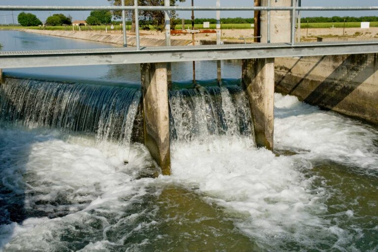
The Delta is the centerpiece of a vast network of natural and built infrastructure that connects water originating in the Sierra Nevada Mountains to the rest of the state. Formed by the confluence of the Sacramento River from the north and the San Joaquin River from the south, it flows out to the Pacific Ocean through San Francisco Bay (Figure 1). Inflows to the Delta come primarily from these two major rivers, along with a few other eastside waterways (e.g., the Cosumnes River, Mokelumne River, and other minor creeks and streams). During high-flow conditions, water from the Sacramento River is diverted into the Yolo Bypass to avoid flooding communities in the Sacramento metropolitan area and to support wetland and aquatic species; this water flows back into Delta channels at the south end of the bypass.
A portion of the water entering the Delta is required to maintain healthy outflows that keep San Francisco Bay saltwater from intruding too far inland. This outflow of “system water” keeps Delta water fresh for communities, fish, and farms. A portion of Delta inflow is consumed by local farms and communities within the Delta (referred to as “in-Delta use” in this report), and another portion is drawn through channels to export pumps in the southern Delta. This exported water is conveyed through the California Aqueduct and the Delta-Mendota Canal to cities and farms in the Bay Area, San Joaquin Valley, Central Coast, and Southern California, making the Delta the state’s central hub for moving water long distances.
In both the Sacramento and San Joaquin Valleys—the northern and southern parts of the Central Valley, respectively—nearly all the unused or uncaptured water flowing through the regions’ rivers makes its way to the Delta. In the southern San Joaquin Valley, rivers are either terminal—meaning that they have no outlet to the ocean and eventually dry up due to diversions—or they are diverted through the Kings River basin via the James Bypass to join the San Joaquin River at Mendota Pool during wet years.
Inflows, outflows, and exports in the Sacramento–San Joaquin Delta
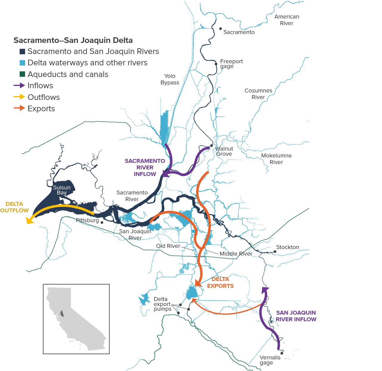
SOURCE: Developed by the authors using map layers from the Delta Stewardship Council. For underlying data, see the accompanying dataset, “PPIC Water Potentially Available for Recharge, 2017 and 2023.”
NOTES: The purple arrows show inflows to the Delta from the Sacramento River (measured at Freeport and the Yolo Bypass) and the San Joaquin River (measured at Vernalis), and the yellow arrow shows Delta outflow (measured at Chipps Island, near Pittsburg). Smaller eastside rivers (Cosumnes and Mokelumne Rivers and some streams) also provide some inflow, as does precipitation in the Delta. The orange arrows show the main pathways for water destined for the export pumps in the southern Delta; a relatively small portion of exports goes directly from the San Joaquin River to the pumps as depicted by the smaller orange arrow north of Vernalis, except during flood periods, when San Joaquin River flows can dominate and flow to the north in the Old and Middle Rivers.
A Complex Suite of Regulations Governs Delta Exports
Given the Delta’s importance for statewide water management, an extensive suite of regulations aimed at protecting water right holders and Delta ecosystems controls how water moves through it. In general, the operators of the State Water Project (SWP; managed by the state) and Central Valley Project (CVP; federally managed by the US Bureau of Reclamation)—the Delta’s exporters—are expected to jointly meet these regulations and maintain water quality in the Delta (Gartrell and Gray 2017). One set of regulations, applicable to the Delta and its tributary waterways, sets minimum outflows to keep Delta water fresh enough for human uses (municipal, industrial, and agricultural) and to provide freshwater habitat for native fishes. Additional regulations are in place to limit harm to threatened and endangered fish, including several runs of Chinook salmon and steelhead trout.
When there is more than enough water flowing into the Delta to meet these requirements, the Delta is said to be “in excess.” In water year 2023 (October 1, 2022 through September 30, 2023), the Delta was in excess for just over half the days in the year. Upstream diversions can take place with fewer regulatory hurdles when the Delta is in excess. However, if diversions take place upstream of the Delta when it is not in excess, exporters may need to make additional reservoir releases or reduce pumping volumes to increase outflow at the expense of their own supplies.
Two other regulations apply to the San Joaquin River specifically and are designed to mitigate negative impacts of export pumping on fish:
- The Old and Middle River (OMR) Flow Limit restricts the rate of reverse flow that export pumps can cause on these two offshoots of the San Joaquin River. Like the San Joaquin River in the Delta, these rivers are tidal (flowing back and forth) but on average they naturally flow to the north. However, the pumps can cause the rivers to flow backwards, which can harm fish (see the orange arrows in Figure 1).
- The Inflow:Export (I:E) Ratio further limits exports between April 1 and May 31 to a small portion of San Joaquin River inflow. When San Joaquin River inflows to the Delta are in flood stage—above roughly 21,000 cubic feet per second (cfs) at the Vernalis gage, as occurred for just over a quarter of days in the 2023 water year—these rules do not apply.
These regulations can cause state and federal projects to restrict their exports even when the Delta is in excess because of insufficient flows coming in from the south side of the Delta. The San Joaquin River is also subject to minimum instream flow requirements imposed at the Vernalis gage; these requirements vary depending on the water year type and time of year. In wet years, the minimum flow requirement can reach as high as 8,620 cfs during the peak snowmelt season (April 15 through May 15).
Taken together, the OMR and I:E rules mean that an increase in upstream diversions when the San Joaquin River is below flood stage can cause significant cutbacks in exports, especially if export pumps would otherwise be operating at full capacity: for every acre-foot (af) of reduction in San Joaquin River inflows, exports would need to be cut by about 0.75 af in April and May, and by 0.5 af in other months. These significant tradeoffs between regular export supplies and upstream diversions for recharge on the San Joaquin River can occur even though this river generally brings a much smaller volume of water into the Delta—and contributes a smaller share of outflow and exports—than the Sacramento River.
Capturing More Water for Recharge in Wet Years
The regulatory dynamics outlined above lie at the crux of current debates about the fairness of new diversions for recharge, especially when those diversions are expedited via simplified permitting processes or bypassing permits altogether. To make the most of available water, Californians need a more refined understanding of how much water can safely be diverted for recharge without harming other users. And where tradeoffs do occur, this information will be important for grounding policy discussions and pointing the way towards fruitful partnerships.
To provide insights on this issue, we examined inflows to the Delta from the Sacramento and San Joaquin Rivers in 2023, a very wet year. We start with the simpler case of the Sacramento River—which has fewer regulations relating to upstream diversions for recharge—as well as two cases examining the more complex San Joaquin River. We apportioned this water into different categories describing both required and potential uses and outlined the tradeoffs that may come into play when this water is used for recharge upstream of the Delta. For this analysis we used daily data on inflows, outflows, exports, in-Delta consumptive use, and other parameters from the Dayflow program, which tracks Delta operations. The accompanying dataset, “PPIC Water Potentially Available for Recharge, 2017 and 2023” (Cole, Gartrell, and Hanak 2024), provides sources, methods, and estimates for the wet years of 2017 and 2023.
An important assumption we applied for all inflow sources is that their contribution to outflow is proportional to their share of inflow on a daily time step. For example, if the Sacramento River provides 75 percent of the inflow to the Delta on a particular day, we assume that it will also contribute three-quarters of the required outflow to the Pacific Ocean on that day. We made the same assumption regarding contributions to exports and in-Delta uses. These are simplifying assumptions made to create a margin of safety in accounting for water supplies across different inflow sources—and notably, to ensure that a significant fraction of water is left in each river regardless of the level of flow in the others. These assumptions do not necessarily reflect any regulatory requirement or management criteria.
The Simpler Case: the Sacramento River
First, we consider the larger Sacramento River’s contributions to outflows, exports, and consumptive use within the Delta. Total Delta inflow from the Sacramento River was about 21.9 maf in 2023 (including flows of about 1.8 maf diverted through the Yolo Bypass for flood control and floodplain habitat). Figure 2 shows a hydrograph of these inflows in thousand-acre-feet of water per day over the course of the water year and categorizes them either as contributions to Delta outflow, exports, or in-Delta consumptive use. The remainder is “available” water, some of which could potentially have been used for recharge efforts.
About 6.7 maf (31%) of Sacramento River inflow supported required outflow; another 4.1 maf (19%) was used for exports and in-Delta use. The remaining 11.0 maf (50%) potentially could have been diverted for recharge. Most of this excess inflow occurred during two major peaks in January–February and March–April, when inflows from the Sacramento River system reached as high as 240 taf per day.
Water potentially available for recharge from the Sacramento River surged during winter and spring storms
Components of Sacramento River inflow, 2023 (taf/day)
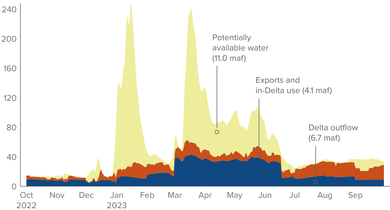
SOURCE: Author calculations using data from the Dayflow program provided by the California Department of Water Resources. For details, see the accompanying dataset: “PPIC Water Potentially Available for Recharge, 2017 and 2023.”
NOTES: Total required outflow for the Delta was estimated from the State Water Resources Control Board D-1641. Taf is thousands of acre-feet; maf is millions of acre-feet. The chart shows total daily inflows measured at Freeport and the Yolo Bypass.
We can divide this water further by splitting it into flood flows—flows above 70,000 cfs at the Freeport gage, the level at which water gets diverted into the Yolo Bypass for flood control—and other potentially available water (Figure 3). About 1.8 maf of flows occurred above flood stage and likely could have been diverted for recharge without a permit to support flood control efforts under the governor’s EOs; these flows primarily occurred during peak inflows in January, March, and April. Meanwhile, the remaining 9.2 maf of other potentially available water may have required a permit from the State Water Board, depending on the local flood conditions in upstream tributaries. Diverting water from either of these categories would not generally entail tradeoffs with Delta exports. The exception is days when the Delta was not in excess (shaded area in Figure 3); in total, these days account for about 0.8 maf of potentially available water. This leaves as much as 8.5 maf of other potentially available water for recharge, in addition to the 1.8 maf above flood stage.
An additional consideration under this scenario would be potential ecological concerns raised by reducing the inflow to the Delta. For example, turbid, early season pulses or “first flush” storms may provide important habitat benefits for some endangered fish like the Delta smelt. Our assumptions about the proportional contributions of each major river to Delta inflow attempt to address this need, but regulators may seek additional limitations on upstream diversions to ensure safety for fish.
It bears noting that much of the potentially available water would have been uncapturable given the physical limitations of existing canals and diversion works, the inability of upstream reservoirs to hold onto the excess water when flows are very high, and the fact that the ground on the valley floor is often saturated at the time when water is gushing through the region’s rivers. Also important to consider is that we calculate available water based on daily volumes flowing into the Delta; in practice, upstream diverters would need to anticipate high flow rates in the Delta by one to several days, depending on their location. Such forecasting ability is not necessarily a given and could limit the ability of upstream users to take advantage of some high flows.
Flood flows are a significant portion of water potentially available for recharge from the Sacramento River
Components of Sacramento River inflow, 2023 (taf/day)

SOURCE: Author calculations using data from the Dayflow program provided by the California Department of Water Resources. For details, see the accompanying dataset: “PPIC Water Potentially Available for Recharge, 2017 and 2023.”
NOTES: Total required outflow for the Delta was estimated from the State Water Resources Control Board D-1641. Flood flows are shown when the river is at 70,000 cfs (140 taf/day), considered flood stage at Sacramento (when flows are diverted to the Yolo Bypass). Taf is thousands of acre-feet; maf is millions of acre-feet. The chart shows total daily inflows measured at Freeport and the Yolo Bypass. On the Sacramento River there are 133 days during which there could be restrictions in diverting water for recharge because the Delta was not in excess, amounting to 757 taf of water.
More Tradeoffs Complicate Diversions on the San Joaquin River
The San Joaquin River is not only smaller than the Sacramento River, it also has greater demand for recharge water, additional layers of regulatory requirements, and significant influence on Delta export operations. As described earlier, the OMR Flow Limit restricts the volume of Delta pumping that can occur relative to the volume of San Joaquin River inflows to limit harmful reverse flows in several key Delta channels. Additionally, the I:E Ratio further limits exports during certain months to a small portion of San Joaquin River inflow, and the San Joaquin River itself has minimum instream flow requirements. All three factors can constrain the availability of water for upstream recharge.
One important factor controlling the amount of net water potentially available for recharge on the San Joaquin River is the ability of exporters to make use of pumping capacity in the Delta. First, we show the breakdown of inflow from the San Joaquin River system if exporters are making full use of their allowable pumping capacity; we call this the “maximum exports” scenario.
In 2023, the total amount of inflow to the Delta from the San Joaquin River was about 7.7 maf (Figure 4). High flows were concentrated in a flashy peak in January and a sustained period between March and July. Of total inflow, 1.5 maf (19%) was needed to support the minimum instream requirements on the river itself; these requirements change depending on the time of year and water conditions. Minimum instream requirements can also satisfy a portion of the San Joaquin River’s contribution to Delta outflow; an additional 1.3 maf (17%) was needed to fulfill the full outflow requirement. Finally, 1.5 maf (19%) would be needed in this scenario for exports and in-Delta use. The remaining 3.4 maf (44%) was water potentially available for recharge, although as we discuss below, diverting some of this water would likely entail significant tradeoffs.
Although flows are lower on the San Joaquin River, a substantial amount of water is potentially available for recharge
Components of San Joaquin River inflow, 2023 (taf/day)
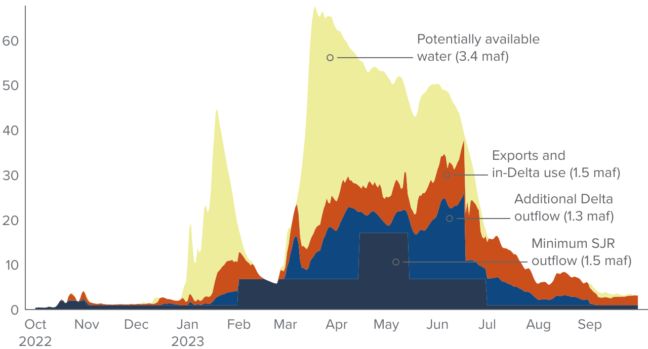
SOURCE: Author calculations using data from the Dayflow program provided by the California Department of Water Resources. For details, see the accompanying dataset: “PPIC Water Potentially Available for Recharge, 2017 and 2023.”
NOTES: Required minimum instream flow for the San Joaquin River and total required outflow for the Delta was estimated from the State Water Resources Control Board D-1641. Taf is thousands of acre-feet; maf is millions of acre-feet. SJR is San Joaquin River. The chart shows total daily inflows measured at Vernalis.
As with the Sacramento River, a portion of the potentially available water would likely have been eligible for flood flow diversion under the provisions of the governor’s EOs. Flood stage on the San Joaquin River typically occurs above 21,000 cfs (42 taf/day) at the Vernalis gage. Of the 3.4 maf of water potentially available for recharge, 1.1 maf were flood flows (Figure 5); diversions of these flows would be unlikely to cause conflicts with other users such as Delta exporters. Unlike the Sacramento River case, there was very little potentially available water on days when the Delta was not in excess (just 0.03 taf). However, we refer to the entire 2.3 maf of potentially available water below flood stage on this river as “tradeoff space” because diverting this water could entail impacts for downstream users. We explore these tradeoffs in more detail below.
Flood flows make up a considerable portion of water available for recharge from the San Joaquin River
Components of San Joaquin River inflow, 2023 (taf/day)

SOURCE: Author calculations using data from the Dayflow program provided by the California Department of Water Resources. For details, see the accompanying dataset: “PPIC Water Potentially Available for Recharge, 2017 and 2023.”
NOTES: Required minimum instream flow for the San Joaquin River and total required outflow for the Delta was estimated from the State Water Resources Control Board D-1641. Flood flows are shown when the river is at 21,000 cfs (42 taf/day) at Vernalis. Taf is thousands of acre-feet; maf is millions of acre-feet. SJR is San Joaquin River. The chart shows total daily inflows measured at Vernalis. On the San Joaquin River there are 50 days during which there could be restrictions in diverting water for recharge because the Delta was not in excess, amounting to 27 taf of water.
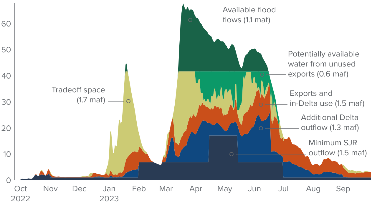
Figure 6 illustrates what would happen if all 2.3 maf of “tradeoff space” water was diverted for recharge upstream of the Delta. In this scenario, less water would enter the southern Delta from the San Joaquin River and the OMR and I:E regulations would begin to restrict export operations. To prevent harmful reverse flows in channels in the south Delta and maintain the required ratio of river inflows to exports, exporters would need to reduce their exports by about 1.4 maf, or 20 percent of typical exports in wet years. Therefore, diverting all 2.3 maf of water in the “tradeoff space” under this scenario would only yield a net gain of about 0.9 maf (“Other potentially available water” in Figure 6) after considering gains from recharge of 2.3 maf and foregone exports of 1.4 maf. Despite the resulting net increases in supplies in the San Joaquin Valley from upstream recharge, exporters could understandably view this scenario with apprehension given the significant impact to their water rights.
Compared to the Sacramento Valley, recharge potential is relatively high in the San Joaquin Valley, which has large areas with suitable soils and ample room to store more water in depleted aquifers (O’Geen et al. 2015; Scanlon et al. 2012). It nevertheless bears noting that not all of the potentially available water could have been captured in this region either, given the physical limitations of existing canals and diversion works as well as surface storage to slow the water down. Widespread expansion of spreading water on working lands in wet years offers promise in capturing significantly more water in this region.
Upstream diversions of “tradeoff space” water from the San Joaquin River would require exporters to reduce pumping in the south Delta
Components of San Joaquin River inflow, 2023 (taf/day)

SOURCE: Author calculations using data from the Dayflow program provided by the California Department of Water Resources. For details, see the accompanying dataset: “PPIC Water Potentially Available for Recharge, 2017 and 2023.”
NOTES: Required minimum instream flow for the San Joaquin River and total required outflow for the Delta was estimated from the State Water Resources Control Board D-1641. Flood flows are shown when the river is at 21,000 cfs (42 taf/day) at Vernalis. Taf is thousands of acre-feet; maf is millions of acre-feet. SJR is San Joaquin River. The chart shows total daily inflows measured at Vernalis.
Another Layer of Complexity: Unused Export Pumping Capacity
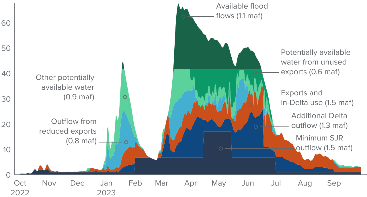
In practice, Delta exporters often operate at less than their full allowable pumping capacity. This can happen when water storage south of the Delta fills up during wet years, or when flow rates are too high to be captured and conveyed within the engineering constraints of available infrastructure. This water is legally available to be used by the exporters but is essentially uncapturable due to these practical limitations. Some of this unused export water could be diverted elsewhere in the watershed to mutual benefit, and without impact to exporters. Here, we consider how this unused export water could influence net water available for recharge upstream of the San Joaquin River—the “actual exports” scenario.
Figure 7 shows the original San Joaquin River hydrograph with an additional carve-out for water available from unused exports: about 0.6 maf in total. These unused exports occurred mostly from April through mid-May at times when pumping in the south Delta through the California Aqueduct and Delta-Mendota Canal was below allowable levels. This water would potentially be available for diversion upstream without entailing additional cutbacks by the exporters, effectively shrinking the amount of water in the “tradeoff space” to 1.7 maf instead of 2.3 maf.
Actual exports often fall below pumping capacity in wet years, leaving additional water potentially available for upstream diversion
Components of San Joaquin River inflow, 2023 (taf/day)
SOURCE: Author calculations using data from the Dayflow program provided by the California Department of Water Resources. For details, see the accompanying dataset: “PPIC Water Potentially Available for Recharge, 2017 and 2023.”
NOTES: Required minimum instream flow for the San Joaquin River and total required outflow for the Delta was estimated from the State Water Resources Control Board D-1641. Flood flows are shown when the river is at 21,000 cfs (42 taf/day) at Vernalis. Taf is thousands of acre-feet; maf is millions of acre-feet. SJR is San Joaquin River. The chart shows total daily inflows measured at Vernalis.
Figure 8 shows how San Joaquin River flows would be divided up under the actual exports scenario if rechargers made full use of potential upstream diversions. A total of 4.3 maf would be required to meet minimum instream requirements on the San Joaquin River, contributions to Delta outflows, and contributions to exports and other uses. Flood flows, likely to be available for recharge diversion without a permit from the State Water Board, would total 1.1 maf and would not require changes in exporter operations. Finally, from the original “tradeoff space” of 2.3 maf (Figure 5), 0.6 maf potentially would be available from unused exports without conflicts to export operations; the remaining 1.7 maf potentially could also be diverted upstream. However, doing so would entail about an 0.8 maf reduction in exports and would leave only 0.9 maf of net additions to water diversions. On the whole, rechargers would gain 3.4 maf of new supplies upstream of the Delta while exporters would need to reduce supplies by about 0.8 maf to make up the additional required outflow.
Unused pumping capacity creates an opportunity to divert “tradeoff space” water upstream with fewer negative impacts for exporters
Components of San Joaquin River inflow, 2023 (taf/day)
SOURCE: Author calculations using data from the Dayflow program provided by the California Department of Water Resources. For details, see the accompanying dataset: “PPIC Water Potentially Available for Recharge, 2017 and 2023.”
NOTES: Required minimum instream flow for the San Joaquin River and total required outflow for the Delta was estimated from the State Water Resources Control Board D-1641. Flood flows are shown when the river is at 21,000 cfs (42 taf/day) at Vernalis. Taf is thousands of acre-feet; maf is millions of acre-feet. SJR is San Joaquin River. The chart shows total daily inflows measured at Vernalis.
Implications for Policy and Practice
Since the 2023 legislation authorizing the recharge of flood flows without a diversion permit, there have been ongoing discussions about further changes in the law and regulatory practice to facilitate groundwater recharge activities. One issue involves clarifying when flood flows should be available for diversion without a permit, including possible legislative tweaks to SB 122 that failed to pass in 2024. Another question concerns whether the State Water Board should authorize additional upstream diversions when inflows to the Delta are still quite high, but below flood stage.
While upstream diverters have sought as much flexibility as possible, exporters have proposed a variety of restrictions to limit upstream diversions when this would impact their water rights. Environmental advocates have emphasized that adequate water should remain in rivers for ecosystem health, another important element in this policy space. Our analysis suggests several important takeaways for advancing beneficial recharge policies:
- The tradeoffs between upstream diversions and exports can be significant, especially for diversions upstream of the San Joaquin River. Given California’s “area-of-origin” laws, some upstream diverters may believe that they should have the right to divert more water upstream, even if it impacts Delta exports. But it is important to recognize the tradeoffs at stake. Of the 7.7 maf of inflow to the Delta from that river in 2023—a high-flow year for the San Joaquin River—only 1.1 maf was coming in at flood stage, and thus available for recharge without impacting minimum Delta outflows or exports. Anything more entails tradeoffs that would need to be worked out in policy discussions.
- The fact that exporters do not operate at capacity during wet years creates more opportunities for recharge. In 2023, an additional 0.6 maf could have been diverted if upstream diverters and exporters had worked together to get that water in the ground upstream of the Delta, and even more in 2017 (1 maf). There are also clear opportunities for mutual benefit by increasing upstream diversions when the San Joaquin River is below flood stage—the remaining 1.7 maf in the “tradeoff space”)—as long as exporters are compensated for the reductions in water they can take at the pumps. Having agreements in place that can be acted on quickly when opportunities arise could benefit all parties.
- More flexibility is needed regarding upstream diversions of flood flows. While the charts above show broad measures of flood stage on both rivers, upstream tributaries can be in flood stage at other times. For example, the upstream community of Planada in Merced County flooded on January 9, 2023, more than a week before the San Joaquin River reached flood stage at Vernalis. Expediting recharge diversions that can reduce flood damage—even if they impact exports—will be important in such situations.
- More flexibility on the criteria for streamlined temporary recharge permits would also be helpful. Stakeholders within both the Sacramento and San Joaquin Valleys have expressed frustrations with the streamlined permitting process, arguing that the State Water Board’s 90/20 rule significantly limits water available for diversions in high-flow periods. Some scientific analyses suggest that more water could potentially be safely diverted at such times. In addition, the State Water Board already provides ways to safely streamline or eliminate the need for a detailed analysis of water availability—the main alternative to the 90/20 rule. This method can be used to avoid onerous research and documentation for individual applicants seeking recharge diversion permits.
- Current updates to environmental regulations in the Delta likely will not change the basic story. The US Bureau of Reclamation recently adopted an updated long-term operating plan to guide the export projects’ compliance with the federal Endangered Species Act (USBR 2024), and additional changes are likely under the State Water Board’s pending update of the Water Quality Control Plan for the Bay–Delta. While these changes would increase the minimum required Delta outflow in some years, they are not likely to significantly affect the water available for recharge in wet-year conditions. For example, even though the new long-term operating plan for the projects reduces exports during dry years—while allowing additional exports in wet years (USBR 2024)—OMR and I:E rules will likely continue to define tradeoffs between exports and upstream diversions on the San Joaquin River. And pending and proposed State Water Board requirements, including the 2018 Water Quality Control Plan focusing on the San Joaquin River tributaries, do not apply in flood conditions (SWRCB 2018).
- Other state and local policies and investments can help make the most of available water. Our survey of recharge experiences in the San Joaquin Valley in 2023 found that authorizing more diversions is just part of the solution. At the state level, a simplified approach to permitting streambed alterations will also be essential to making recharge projects operational, for instance. And local policies that incentivize landowners to put more water on their land can help unlock the enormous potential of recharge on farmland—a cost-effective way to get floodwaters out of harm’s way and into the ground for future use. Getting more water underground will also require strategic investments—supported by state and local funding—in infrastructure and water accounting frameworks.
Conclusion
As California adjusts to climate-driven shifts in the cadence of water availability and looming cutbacks in underground supplies under the Sustainable Groundwater Management Act, groundwater recharge is positioned to be a powerful adaptation tool. As shown in our surveys of recharge in the San Joaquin Valley for 2017 (Hanak et al. 2018) and 2023 (Peterson, Hanak, and Joaquín Morales 2024), this strategy is rapidly gaining traction, yet regulatory and logistical uncertainties remain about how it can be implemented most effectively. In this report, we expanded on our initial estimates of water that could have been used to support recharge in 2023 by examining in greater detail the water balance in the Sacramento–San Joaquin Delta. We found that while there were ample opportunities for recharge along both the Sacramento and San Joaquin Rivers, partnerships are needed to mitigate conflicts between upstream recharge diverters and exporters in the Delta. These partnerships, as well as improved flexibility in the ability to divert water upstream of the Delta, will be key to unlocking recharge opportunities in future wet years.
Topics
Freshwater Ecosystems Paying for Water San Joaquin Valley Water Supply Water, Land & Air