
Table of Contents
Key Takeaways
Successful implementation of the 2014 Sustainable Groundwater Management Act (SGMA) is vital to the long-term health of the San Joaquin Valley’s communities, agriculture, environment, and economy. But the transition will be challenging. Even with robust efforts to augment water supplies through activities like groundwater recharge, significant land fallowing will be necessary. How the valley manages that fallowing will be paramount to protecting the region’s residents—including the growers and rural, low-income communities who will be most directly impacted by the changes. With coordinated planning and robust incentives, the valley can navigate the difficult water and land transitions coming its way and put itself on a path to a productive and sustainable future.
- Water trading will be crucial to the valley’s efforts to manage increasing water scarcity. Trading surface water and groundwater can reduce the cost of adapting to cutbacks because it enables water to move to uses that generate the highest returns. Trading must be implemented carefully, however, to ensure that the negative impacts of relocating water use are tracked and managed. Investments in new supply will help, but they likely will not make up for needed cuts in pumping. →
- Accelerating farmland repurposing efforts will help to ensure SGMA’s success. Even in the best-case scenario, some 500,000 acres may need to be fallowed in the San Joaquin Valley. It will be important to reduce the negative consequences of this transition. Promising alternative land uses include solar development, water-limited cropping, habitat restoration, recharge basins, and water-efficient new housing. →
- Increased coordination will help the region scale up its efforts. Water trading, new supply projects, and some types of land repurposing will require unprecedented partnerships across jurisdictional lines. GSAs and their local, state, and federal partners should adopt basin-wide and regional approaches—and more links across sectors—to take advantage of opportunities and ensure success. →
- Investments and incentives will grease the wheels of progress. Robust funding and supportive regulations are key. Investing in water infrastructure and energy transmission will help expand water recharge efforts and bolster solar development. Updating and aligning regulatory and fiscal incentives—and taking advantage of local, state, and federal funding—will aid the transition to groundwater sustainability and help ensure that agriculture continues to thrive. →
Introduction
Implementation of the Sustainable Groundwater Management Act (SGMA) of 2014 will bring long-term benefits for California’s agricultural communities, environment, and economy. This law directs local groundwater sustainability agencies (GSAs) to plan for and execute the transition to sustainable groundwater use—avoiding undesirable results of pumping and securing groundwater availability into the future. Managing groundwater reserves sustainably is a critical hedge against the changing climate, which is bringing warmer, more intense droughts and increasingly volatile precipitation.
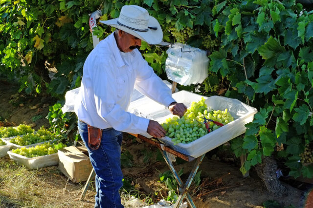
But implementing SGMA will come with costs. The San Joaquin Valley, home to 4 million people and most of the state’s critically overdrafted areas, is ground zero for difficult decisions around SGMA. In two recent studies (Hanak et al. 2019, updated in Escriva-Bou et al. 2023), we showed how flexible approaches to managing available water—by facilitating surface and groundwater trading—can complement strategies to augment supplies. Together, these approaches can significantly reduce the costs of achieving sustainability. Even so, reducing pumping by the valley’s largest water user—agriculture—will be unavoidable. In the most extreme scenario, close to 900,000 of the valley’s 4.5 million acres of irrigated cropland could go fallow to meet the needed reductions in water use.
With nearly 20 percent of the San Joaquin Valley’s irrigated agricultural footprint at risk, it is crucial to consider how to transition these lands to alternative productive uses that consume much less water. In more than seven years of conversations with diverse valley stakeholders—including water and land managers, farmers, researchers, and representatives of local agencies, communities, and environmental organizations, among others—one recurring theme has emerged: haphazard, unplanned fallowing is widely viewed as a pathway to undesirable outcomes for the valley’s economy, environment, and community well-being. Concerns include widespread land degradation due to noxious weed infestations and topsoil loss, setbacks to the valley’s progress on air quality, missed opportunities to create habitat connectivity, and heightened risks of economic disruption in this heavily agricultural region.
Progress on SGMA implementation. SGMA implementation has advanced considerably in the past few years. Under the law, GSAs are responsible for submitting and implementing groundwater sustainability plans (GSPs), and the state may intervene if it deems these plans inadequate. The plans must contain detailed estimates of water supplies and demands, as well as projects and actions to bring basins into balance by the early 2040s while avoiding undesirable impacts of pumping along the way.
The valley’s GSAs generally met the deadlines for submitting their first GSPs—2020 for the 11 critically overdrafted basins and 2022 for the four other basins. But the review process has been rocky. The California Department of Water Resources (DWR) required revisions to plans in all 11 critically overdrafted basins, citing insufficient coordination and a failure to adequately address undesirable results, such as land subsidence and reduced drinking water reliability in rural communities. DWR has approved revised plans in four of these basins but has deemed the revised plans inadequate in six others. (As of this writing, plans in the five remaining basins are still under review.) The basins with inadequate plans have been referred to the State Water Board, which will determine whether to designate the basins as probationary and directly oversee pumping (California Department of Water Resources 2023; California State Water Resources Control Board 2023).
Meanwhile, GSAs and their members have started executing their plans. Many plans emphasize projects to boost water supplies—notably through groundwater recharge—and the abundant rains of 2023 have spurred significant new activity (Peterson and Bardeen 2023). Some GSAs are directly addressing the undesirable impacts of pumping, for instance, through programs to ensure drinking water supplies for domestic well users. And some have begun the difficult task of reducing groundwater use—by establishing pumping allocations, incentivizing water users to pump less (e.g., with extraction fees), launching local groundwater trading, and offering credits for fallowing land while following best management practices for soil protection.
Considering land use alternatives. In our recent work, we have taken a closer look at several land use alternatives that show promise for mitigating the downsides of widespread land fallowing. For example, developing utility-scale solar energy on former cropland is a potentially attractive option that can help California meet its clean energy goals, though one that is constrained by transmission capacity and permitting hurdles (Ayres et al. 2022). Another option involves keeping agricultural lands in production with water-limited cropping systems such as winter forages (Peterson, Pittelkow, and Lundy 2022). Small doses of supplemental irrigation can allow growers to establish these flexible crops across a wide swath of the valley, and with the right incentives, they could help increase the nimbleness of farming operations. As lands transition away from intensively irrigated crop production, opportunities may also arise to restore valuable desert and upland habitat—and even some riparian and wetland areas (Hanak, Peterson, and Hart 2022). Lands dedicated to expanding groundwater recharge can also serve as intermittent wetlands (Hanak et al. 2019). Finally, in a region that may continue to see considerable population growth, water-efficient new development could help close the groundwater gap while supporting local economies (Ayres et al. 2021a).
Such synergies can help to offset the costs of transitioning to groundwater sustainability. But there is more to the conversation than “which land use, and where?” Adaptation measures—including both water trading and land repurposing—could address potential problems, but also might cause unintended consequences. To ensure a balanced and beneficial transition to groundwater sustainability, substantial changes will be needed to improve how institutions work together, and to tailor fiscal and regulatory programs to the new realities. It will be essential to align incentives, coordinate policies and approaches, and establish adequate streams of funding.
About this report. We begin by recapping our findings on the size of the valley’s water deficit, what this could mean for land fallowing, and how supply and demand management tools could help bring down the costs of water scarcity. We then drill deeper into how water trading could play out on the landscape, and we explore the opportunities and potential tradeoffs of sharing water in this way. We bring together our findings on the promise and limitations of various alternatives for lands at risk of losing their water. Finally, we offer recommendations on how to manage water and farmland transitions in the most constructive way in order to secure a promising future for this important region. If successful, the San Joaquin Valley would provide valuable lessons for other agricultural regions in California and across the West that are also facing growing water scarcity.
A technical appendix provides additional background on many of the analyses presented here.
Addressing Water Scarcity in the Valley
Valley-wide, we estimate that average annual farm water availability will decline by 3.15 million acre-feet (maf) by 2040—roughly 20 percent of current supplies (Escriva-Bou et al. 2023). SGMA-related actions to end groundwater overdraft account for most of this decline (2.7 maf), but climate change and new environmental flow requirements in local rivers and the Sacramento–San Joaquin Delta are likely to compound these effects (Figure 1a). Simply put, there won’t be enough water to sustain the current irrigated agricultural footprint. Some land will have to be fallowed, causing losses of agricultural revenues and jobs.
Throughout this report, we use the term “fallowing” to refer to the removal of land from intensive irrigated production, whether for a few seasons or for permanent retirement or repurposing. How fallowing plays out across the region will depend in part on local water supply conditions and cropping choices, which vary substantially both within and across the valley’s 15 basins. Lands receiving little to no surface water are more reliant on groundwater and more likely to experience pumping cutbacks (Figure 1b). And supply cutbacks are more costly when they require the fallowing of perennial crops, which now cover more than 60 percent of irrigated acreage in the valley (Figure 1c).
Water scarcity impacts could vary widely both within and across groundwater basins, reflecting local differences in surface water availability and cropping choices

SOURCES: (a) PPIC estimates from Escriva-Bou et al. (2023); (b) PPIC estimates from Escriva-Bou et al. (2023); (c) DWR (LandIQ estimates for 2018).
NOTES: Af is acre-feet; taf is thousands of acre-feet; ac is acre. E-flows represent reductions in supply due to more stringent regulations on minimum environmental flows. Panel (a) shows applied water reductions from different supply constraints—SGMA, new environmental flow requirements, and climate change—for each of the San Joaquin Valley’s 15 groundwater basins. Panel (b) shows average annual availability of surface water for irrigated lands in 49 local areas (or subunits) that have similar access to surface water within basins (see Figure A1 in the technical appendix for a display of these areas). Areas shown in white are urban areas, managed wetlands, and other open space and non-irrigated rangeland. Areas with less than 3 af/acre typically rely on at least some groundwater; those in the <0.2 af/acre category are entirely dependent on groundwater. Perennial crops mapped in panel (c) include almonds, pistachios, and grapes, among others; annual crops include cotton, corn, alfalfa, and tomatoes, among others.
Panels (a) and (b) show PPIC’s standardized estimates of overdraft and surface water availability, using information for water years 2003–10. As described further in Escriva-Bou et al. (2023), these are the only years for which comparable data are available in all the valley’s GSPs, allowing a consistent valley-wide analysis; this period is also broadly representative of the valley-wide level of overdraft for the 30-year period 1988–2017. Local conditions may differ from what’s shown here. First, in some of our 49 local areas, we group multiple water districts or GSAs with roughly similar deliveries; panel (b) shows averages across the whole local area rather than individual water districts. Second, increased environmental flow requirements starting in 2009 have likely reduced the long-term average availability of surface water in basins that receive agricultural service contract deliveries from the Central Valley Project or deliveries from the State Water Project (e.g., Westside and parts of Kern). This could further increase the long-term water deficit in some basins.
The San Joaquin Valley floor is covered by 15 distinct groundwater subbasins (herein, “basins”). We modeled economic scenarios for 49 local areas within these basins—grouping together lands served by a much larger number of local water districts if they have relatively similar access to agricultural water supplies. We explored two management approaches that can significantly mitigate the overall socioeconomic losses from growing water scarcity in the valley: expanding water supplies and managing demand by increasing water trading. Markets for trading surface water are already widespread in the valley, but groundwater markets are still nascent. Expanding water trading will not substantially reduce fallowing because it does not increase water availability, but it does reduce economic impacts by moving water to crops and locations where cutbacks would be most costly for growers and the regional economy. Expanding supplies—where feasible—can both reduce fallowing and further mitigate economic costs. Water trading also works well in conjunction with a key supply enhancement strategy—groundwater banking—where parties store water in aquifers for later use.
Institutional reforms would be needed to facilitate both demand and supply approaches. New infrastructure investments would also be needed to facilitate some trading as well as new supplies. Here, we summarize some high-level takeaways from this analysis. We then explore the implications of different water trading scenarios for local land use, and we consider how trading might help or hinder GSAs’ ability to address the undesirable effects of groundwater use and mitigate the environmental and social impacts of land fallowing.
Using Demand and Supply Tools to Bring Basins into Balance
Our modeling compares recent conditions with those expected in 2040, when SGMA and other stressors could reduce availability by 3.15 maf/year on average, out of a total supply of 16 maf/year. We look at four trading scenarios to bring water demand down by this amount, with different degrees of water trading, and two growth scenarios: increased water supplies and agricultural productivity growth. Each scenario builds on the prior one:
- No trading. In this extreme case, water management is completely inflexible—with no water trading between farms, and no flexibility within farms to move water from one field or crop to another. Declines in acreage for all crops are proportional within the 49 local areas that have similar water availability. In practice, farmers have some flexibility to move water to different crops on their own lands, even when water trading with other growers is restricted.
- Local trading. Surface water and groundwater can be shared flexibly within each of the 49 local areas. Current practice lies somewhere between the no trading approach and this one; many water agencies allow local surface water trading, but groundwater trading is still rare.
- Basin trading. Surface and groundwater can be shared flexibly across local areas within each of the valley’s 15 groundwater basins. For some basins with large internal differences in water availability—such as Turlock, Kings, Kaweah, and Kern (Figure 1b)—achieving this level of trading would require substantial changes in practice, as well as some new infrastructure.
- Valley trading. Surface water can be traded valley-wide, but groundwater can only be traded within basins—consistent with greater legal restrictions on this resource. This is another extreme scenario; although surface water trading is already a common way to secure regular supplies in some areas, additional water movement might be constrained by regulations or the lack of infrastructure.
- Expanded supplies. Up to 1 maf of new water supplies are added—notably, by capturing and storing more water from large storms, but potentially also by importing more water from other regions. Supplies are shared flexibly in areas with strong demand.
- Increased productivity. Agricultural productivity grows at half the rate of the past four decades.
Our economic analysis considers the impacts to regional agricultural employment and GDP—a broad measure of regional economic activity. We define agriculture broadly to include crop production plus sectors that use these crops as inputs: beef and dairy, and food and beverage processing. Figure 2 summarizes the results, which are explored more fully in Escriva-Bou et al. (2023).
In the worst-case scenario—with no new supplies and no trading—nearly 900,000 acres of farmland would be fallowed, almost 50,000 jobs would be lost, and regional economic activity would decline by 2.3 percent (Figure 2). In contrast, even without adding a drop of new water, trading would significantly reduce regional economic losses: local trading would cut GDP losses by 33 percent, basin trading by 42 percent, and valley trading by 50 percent. New supplies would further soften the blow, as would further advances in productivity. But even in the most optimistic scenario—with one million acre-feet of new supplies—almost 500,000 acres would need to be fallowed annually. This underscores the importance of finding productive alternative uses for these lands.
In the rest of this report, we focus on the scenarios with no new water supplies—considering both how land fallowing might change with different types of water trading, and what this might mean for the suitability of various land use alternatives. Efforts to expand water supplies—particularly by increasing the capture and storage of flows from wet years—could significantly reduce the need to fallow lands. But there is still great uncertainty about how much new water is feasible, and how supply investments will play out on the landscape.
Water trading, new supplies, and productivity gains can temper the impacts of farm water reductions expected by 2040

SOURCE: PPIC estimates. See technical appendix of Escriva-Bou et al. (2023).
NOTES: These scenarios report average annual impacts for 2040 relative to current conditions, assuming irrigation water cutbacks of 3.15 maf from SGMA, climate change, and new environmental flows. Each scenario builds on the water availability and management assumptions of the previous scenario. New water in the last two scenarios is assumed to cost $500/acre-foot.
Water Trading Reduces the Costs of Managing Demand
Water trading reduces the costs of adapting to cutbacks because it enables water to go to activities generating the highest returns. Here, we focus on farm-to-farm trading, but trading also supports the water demands of communities and ecosystems (Hanak, Sencan, and Ayres 2021). The trading of surface water is already common in some parts of the valley, and SGMA’s new groundwater governance structures lay the foundation for local and basin-wide groundwater markets to develop as well (Ayres et al. 2021b). The diversity of crops and geographic differences in expected water cutbacks create strong incentives for valley growers to further expand trading in coming decades.
In particular, farmers growing more-profitable crops like vegetables and perennial fruits and nuts—e.g., almonds, pistachios, and grapes—will seek to purchase water from those growing less-profitable field crops like alfalfa and cotton. In the no trading scenario, perennials take the biggest hit: they make up two-thirds of the fallowed acreage (66%). With basin trading, that share drops to just over a quarter (28%), and with valley-wide trading of surface water, it falls even further (12%). The flip side is a sharp decline in alfalfa, an input to the dairy industry. It virtually disappears under valley trading (see below for a discussion of the possible impact on dairy and related industries). Large drops would also occur in other field crop acreage (except corn, a special case in this region, because of the key roles it plays in animal diets and waste management).
Figure 3 shows how the fallowing risk—that is, the likelihood that specific acreage will be fallowed by 2040—might play out geographically. With no trading, all crops within each of the 49 local areas face the same level of risk, and there are sharp differences in risk both within and across the region’s 15 basins. Local trading reduces fallowing risk for perennials, vegetables, and corn within each of these local areas, and increases that risk for alfalfa and other field crops. Basin trading smooths out within-basin differences, as lands facing larger water cutbacks acquire surface and groundwater from lands in other parts of the basin—especially in Eastern San Joaquin, Kings, Modesto, and Turlock. And with valley-wide surface water trading, the overall fallowing risk declines considerably in basins with large water deficits and a high share of perennials, like Madera, Kern, and Chowchilla. Fallowing risk increases in basins with substantial surface water and a high proportion of alfalfa and other field crops—especially Delta–Mendota and Tulare Lake.
Trading water could significantly shift the location of fallowing in the valley

SOURCE: PPIC estimates, based on the analysis in Escriva-Bou et al. (2023).
NOTES: Land fallowing risk categories are defined as follows: “No risk” is less than 1 percent probability of the land being fallowed by 2040, “low risk” is between 1 and 10 percent, “medium risk” is between 10 and 25 percent, “high risk” is between 25 and 50 percent, and “very high risk” is more than 50 percent. The valley-wide average fallowing risk ranges from 18–19 percent across scenarios; see Figure 2 for the overall estimates of acreage that would be fallowed annually.
For a variety of reasons, the valley may not see all the trading activity that our modeling predicts; in practice, some combination of these scenarios is more likely. A premise of water trading is that it occurs voluntarily—with willing buyers and willing sellers. Some farmers might decide against selling their water, even if they could gain financially from doing so. Market conditions may also evolve, rebalancing the relative profitability of different crops (for instance, if pressures on hay acreage in other western states give a sustained boost to local alfalfa prices).
Institutional barriers can also prevent growers from making mutually beneficial trades. Permitting and processing requirements are examples of transaction costs that can limit access to the market. Some types of trades also face outright restrictions. For instance, many local water districts restrict sales of surface water out of their boundaries, and project operating rules limit the flexibility to sell Central Valley Project or State Water Project water to parties outside of these large federal and state project service areas (Gray 2021; Ayres et al. 2021b). Groundwater trading can only happen if GSAs set up solid accounting and tradable allocations—something SGMA authorizes but does not require.
Infrastructure can also be a constraint. While groundwater trading within the same basin can be accomplished without physically moving the water from seller to buyer, additional water conveyance may be needed to move surface water to some of the places where buyers would like to use it—such as the fully groundwater-dependent lands shown in Figure 1b.
And finally, in some situations moving water might be limited to avoid unintended negative impacts on “third parties”—those other than the willing buyers and sellers. We explore some of these concerns next.
Addressing Concerns About Water Trading and Pumping
Groundwater pumping and land fallowing can both have negative consequences for communities. Questions about the potential negative impacts of expanding water trading in the valley fall into two main categories. First, will new groundwater trading make it harder to avoid the undesirable results of groundwater use, such as land subsidence and dry wells? And second, will shifting the location of land fallowing through water trading cause unintended environmental and socioeconomic consequences, such as more exposure to dust pollution, or economic impacts to certain groups, such as small farmers, the dairy industry, or particular counties? Our geographically explicit modeling of how trading might alter water and land use provides some insights into these questions.
Effective and responsible water trading must be conducted in ways that address significant harm to other water users and ecosystems (Ayres et al. 2021b). Such protections are already in place for surface water trading—and it will be crucial to establish them as new groundwater markets develop. When trading would cause significant impacts, options may include mitigation (such as providing affected parties with an alternative water supply) or limiting trading activity, for instance by establishing “no-buy” zones for groundwater where increasing pumping would be too costly to mitigate.
The bottom line? Managing water scarcity is a balancing act. While it may be necessary to exercise special caution about water trading in some places, being able to move water through the market would not only reduce overall economic costs, it may also help reduce some third-party impacts of pumping and land fallowing.
Achieving groundwater sustainability will address many negative impacts of overpumping
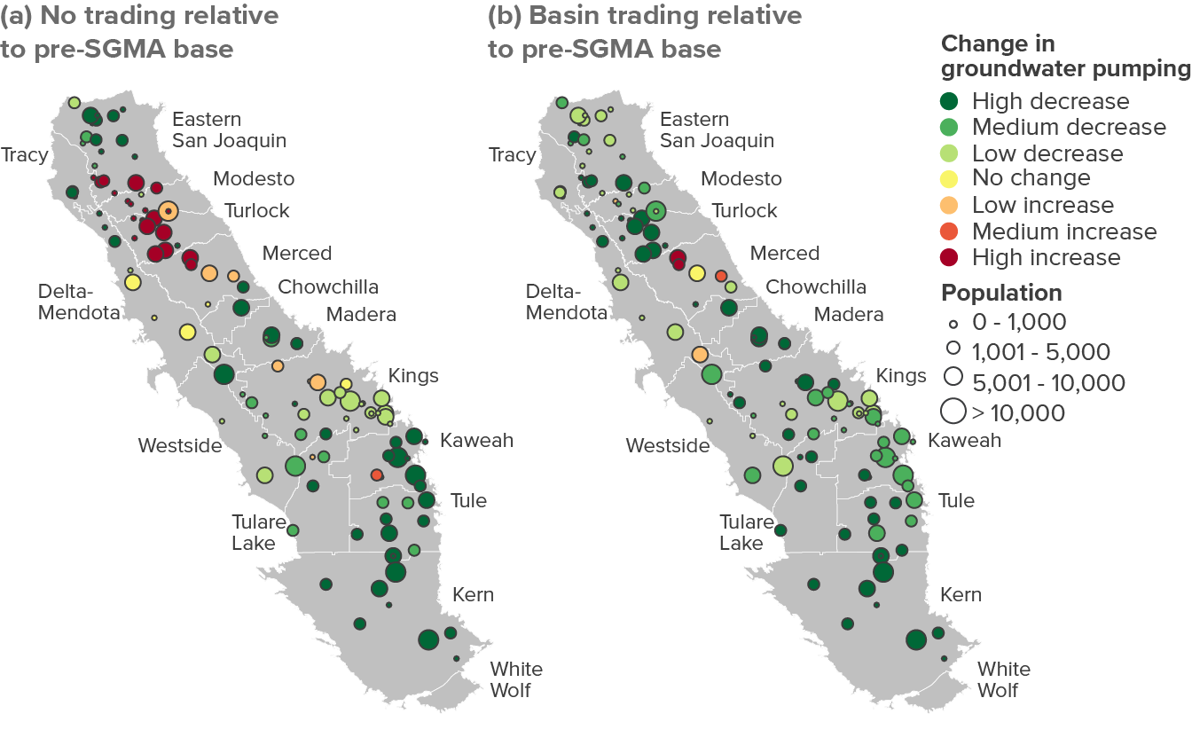
Discussions about the impacts of groundwater trading sometimes overlook the fact that groundwater overdraft itself causes major third-party impacts, such as subsidence and well failures. In many local areas, attaining sustainability could require groundwater pumping to decline significantly—by more than 25 percent relative to the pre-SGMA baseline (Figure 4a). The main exceptions lie in areas not currently facing large (or any) overdraft. This includes some areas in the northeast (shown in red and orange on the maps), where farmers would increase pumping in response to new environmental flow requirements and climate change impacts that reduce their surface supplies. Our modeling suggests that groundwater trading, rather than causing negative impacts, could actually spread the benefits of ending overdraft more broadly: with basin-wide groundwater trading, pumping would decline in more areas (Figure 4b).
These large, widespread declines in pumping will likely address many of the undesirable results of overdraft. But there will be an ongoing need to manage the local impacts of groundwater use, even after basins have attained long-term balance. For example, subsidence or well failures may still occur during extended droughts. And there will still be impacts from continued overdraft as the region transitions to sustainability. Both factors could warrant additional local limits on pumping, as well as limits on groundwater trading.
With or without trading, upcoming water restrictions will reduce groundwater pumping in most areas relative to pre-SGMA levels

SOURCE: PPIC estimates, drawing on Escriva-Bou et al. (2023). For details see the technical appendix.
NOTES: The maps show shifts in groundwater pumping to attain sustainability relative to the pre-SGMA baseline, considering supply cutbacks from SGMA, new environmental flows, and climate change by 2040 (see Figure 1a). “Low” represents a change of less than 10 percent, “medium” a change between 10 and 25 percent, and “high” a change greater than 25 percent. In some cases, large percentage changes may reflect small changes in actual volumes. Panel (a) assumes no trading and proportional groundwater use changes within each of 49 local areas, while panel (b) allows for trading of surface and groundwater within basins. In the no trading scenario, areas with pumping increases currently do not have overdraft; they increase pumping to compensate for the loss of surface water from climate change and new environmental flow requirements.
Subsidence threats may warrant special pumping limits
Excess groundwater pumping can compact soil and rock layers, causing land to sink and damaging infrastructure. Subsidence has been occurring in the San Joaquin Valley for almost a century, but it accelerated during the 2012–16 drought, and again during the 2020–22 drought. Subsidence has damaged some critical water conveyance arteries, including the Friant-Kern Canal and the California Aqueduct, and it has also affected other water supply, flood control, and transportation infrastructure. Subsidence can also permanently reduce the capacity of aquifers to store water.
But subsidence is a complex phenomenon (Jones et al. 2021). Soil and aquifer characteristics make some areas more vulnerable than others. And the magnitude of subsidence is not necessarily linked to the damage caused. Figure 5 illustrates both issues by juxtaposing recent estimates of subsidence and overdraft. First, while some lands with the most subsidence are in major overdraft areas—for instance, the sizable bowl between the Kaweah, Tule, and Tulare Lake basins—other regions with substantial overdraft have not subsided significantly in recent years. Second, less severe amounts of subsidence have caused major damage along the Friant-Kern Canal. This infrastructure relies on small but precise inclines to convey water by gravity without using energy, and slight changes in the foundations can cause large reductions in capacity.
The impact of overdraft on subsidence varies considerably across the valley

SOURCES: (a) Tre Altamira inSAR subsidence data from the CA Department of Water Resources; (b) PPIC estimates from Escriva-Bou et al. (2023).
NOTES: Ft is feet. Af/ac is acre-feet per acre. Subsidence recovery areas refer to places where cumulative subsidence was estimated to be negative during the period examined. Panel (a) highlights key water conveyance infrastructure that is vulnerable to subsidence. Colored areas in panel (b) are irrigated cropland.
Given the complexities of subsidence, GSAs will need to carefully monitor the impacts of pumping in vulnerable areas, even after bringing their basins into long-term balance. Where subsidence effects are especially costly, it may be necessary to set stricter pumping limits and to create “no-buy” zones for groundwater to meet SGMA’s requirement of avoiding significant undesirable results. Market tools could nevertheless help reduce the costs of attaining sustainability in such areas. Facilitating more access to surface water purchases could reduce pressure on groundwater supplies. And allowing farmers in sensitive areas to sell their groundwater allocations could shift pumping to other areas while providing some compensation for local cutbacks. Targeted efforts to recharge groundwater could also help stabilize some of these lands, provided aquifer characteristics enable recharge into the affected portions of the aquifer (Smith and Knight 2020). Finally, transitional financial support may be warranted for growers facing large pumping cutbacks to protect critical infrastructure.
Groundwater trading could reduce pressure on rural drinking water supplies
Groundwater is the primary source of drinking water in the valley. More than half a million rural, mostly low-income residents are served by small community water systems or domestic wells—particularly in the more populous eastern basins. These wells tend to be relatively shallow and more likely to run dry when groundwater levels fall (Escriva-Bou 2019). And as with subsidence, these problems accelerate during droughts. In each of the recent droughts, roughly 2,000 of the region’s domestic well users reported shortages, and many small community wells lost supplies.
Figure 6 summarizes our predicted changes in groundwater pumping for crop irrigation by 2040 around the small communities where many of the valley’s rural residents live. Under the no trading scenario, there would be large decreases in agricultural groundwater pumping around many communities, but roughly a quarter of rural communities (concentrated in the Tracy, Eastern San Joaquin, Turlock, Modesto, and Merced basins—areas shown in red or orange in Figure 4a) could experience falling groundwater levels as farmers increase pumping to compensate for surface water cuts from climate change and new environmental flow requirements. Basin trading has the potential to reduce drinking water risk for low-income rural communities because it shifts agricultural pumping reductions to areas with more rural residents and shifts pumping increases to areas with fewer residents (also compare Figures 4a and 4b above). This happens because areas with higher agricultural demand for groundwater tend to be less populated. We find similar patterns for rural residents who rely on domestic wells (see Figure A8 in the technical appendix).
Groundwater trading within basins could help relieve the impacts of agricultural pumping on rural community drinking water wells
SOURCE: Small community water system locations: State Water Resources Control Board; pumping change estimates: PPIC. For details see technical appendix.
NOTES: The figure shows small community water systems that are located near significant irrigated cropland (>250 acres of crops within a 1.5-mile buffer zone around the community). Some buffers include multiple systems in close proximity. The circles depicting communities by population size are larger than scale. The colors show modeled changes in groundwater pumping in these buffer zones by 2040, relative to the pre-SGMA baseline, taking into account reductions in irrigation water use to attain sustainability. “Low” represents a change of less than 10 percent, “medium” a change between 10 and 25 percent, and “high” a change greater than 25 percent. “No change” is plus or minus 1 percent or less. In some cases, large percentage changes may reflect small changes in actual volumes. The no trading scenario assumes proportional groundwater use cutbacks within each of the 49 local areas, while the basin trading scenario allows for trading of surface and groundwater within basins (Figure 4). The estimated population served by these small community systems is 411,000. See Figure A8 in the technical appendix for an analysis of pumping changes for the roughly 160,000 people served by domestic wells.
As with subsidence, GSAs will need to continue assessing the local effects of groundwater pumping—including shifts caused by groundwater trading—to avoid significant impacts on drinking water supplies. There are also important transitional issues to consider on the road to 2040, as persistent overdraft is likely to impact basin conditions for some time. Imposing restrictive pumping thresholds sooner could prevent wells from going dry, but this would cause costly cuts in agricultural activity. In some areas, mitigation plans to proactively replace at-risk wells might be cheaper than the agricultural losses related to steeper groundwater cuts (Jezdimirovic, Hanak, and Escriva-Bou 2020b).
Addressing Concerns about the Impacts of Water Trading and Land Fallowing
Groundwater pumping causes one set of issues, including well failures and land subsidence. Land fallowing causes another important set of impacts that must be managed. Dust exposure is a particular risk for low-income rural communities. And concentrated fallowing could limit economic opportunities for farms of different sizes or certain sectors and localities. By shifting where land is fallowed, water trading could affect these localized impacts, potentially meriting transitional assistance.
Trading could slightly shift fallowing near communities with high dust risk
As we discussed in an earlier PPIC report, dust mobilized by wind erosion and other soil-disturbing activities on fallowed lands can travel miles under the right conditions; when inhaled, it can cause a host of negative impacts, ranging from respiratory and cardiovascular ailments to reductions in educational attainment (Ayres, Kwon, and Collins 2022). It can also spread the fungal spores that cause Valley fever, a potentially life-threatening infection.
An increase in fallowing is most likely to affect dust exposure in the valley’s rural communities, many of which are surrounded by agricultural land. Because farming also generates dust, the net impacts of land fallowing are not always clear. But to provide a general sense of how dust exposure could shift, Figure 7a maps the communities served by small water systems, highlighting those where soils are considered highly erodible by wind. Roughly 177,000 residents live in these high-risk communities. The four bars in Figure 7b show how fallowed acreage in the areas surrounding these communities might increase by 2040 under different water trading scenarios. The picture that emerges is mixed: compared to the no trading scenario (where 29,000 acres would be fallowed), basin trading would increase fallowing near high-risk communities somewhat (to 34,000 acres). But local and valley trading would actually result in a bit less fallowing around these communities (24,000 acres) than the no trading case. As we saw above, basin trading tends to move water toward areas with fewer people, and to decrease farm water use (and increase fallowing) in more populous areas.
That said, the overall difference in fallowed acreage across these scenarios is not large, and it will be important to manage fallowed lands to protect communities in high-risk areas from wind-blown dust, with or without trading. Cover cropping and other methods have proven effective at keeping fallowed soils from eroding (Ayres, Kwon, and Collins 2022).
Water trading could slightly shift fallowing risk near communities where soils are most prone to wind erosion

SOURCES: Author calculations, using Walkinshaw et al. (2021) (Wind erodibility index), State Water Resources Control Board (water system mapping), and fallowing risk (Escriva-Bou et al. 2023).
NOTES: The map plots rural communities with significant (>250 acres) amounts of agricultural land within a 1.5-mile buffer. Dust risk categories use the wind erodibility index (WEI); the cutoff value between high and low is a WEI value of 86. The bars show expected acreage fallowed from water cutbacks around communities with highly erosive soils; buffers around communities are 1.5 miles, adjusted to account for the footprint of the community. Additional details are available in the technical appendix and Ayres et al. (2022). Total population in the high-risk communities is roughly 177,000.
Smaller farms tend to be found in areas facing less water scarcity, and some could benefit from trading
Farms in the valley come in all sizes, from large enterprises spanning multiple basins to single parcels with fewer than 10 acres (Figure 8). Some have raised concerns that SGMA implementation could put smaller farms at a disadvantage, particularly if water trading expands significantly. To gain insight on these issues, we conducted a detailed geographical analysis of land use and water conditions by farm size, using county real estate records on ownership to identify farms (for details, see Ayres, Joaquín Morales, and Hanak (2023) and the technical appendix).
Most farms in the valley are small, and they face lower fallowing pressures with SGMA. Larger farms cover more acres and face greater declines, with or without trading
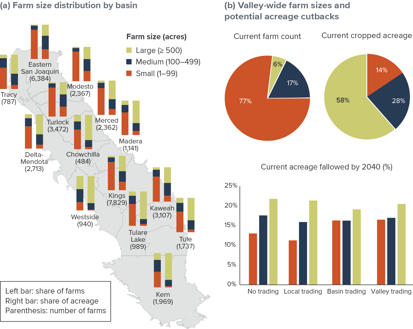
SOURCE: PPIC estimates (see technical appendix for details).
NOTES: Panel (a) shows the distribution of farms of different sizes across basins, along with their share of irrigable acreage (including both cropped and idle land) and basin-level farm counts. Multi-basin farms are included in every basin where they hold land. Panel (b) shows valley-wide totals for current farm counts and cropped acreage (pie charts) and shares of current acreage that would be fallowed by 2040 under the four different trading scenarios (bar chart).
Among the key takeaways: First, while smaller farms (those with less than 100 acres) are present across the region, they make up a much bigger share of all farms—and a larger share of cropped acreage—along the valley’s east side, especially in the Eastern San Joaquin, Modesto, Turlock, and Kings basins (Figure 8a). Second, smaller farms tend to be situated in areas facing less water scarcity than larger farms. To see this, compare acreage declines by 2040 in the no trading scenario, which administers cutbacks in water availability with no adjustments in where water is used (Figure 8b). This pattern reflects the fact that many smaller farms are located in districts with relatively senior surface water rights.
Third, water trading would not substantially change this picture. With local trading, small farms could experience slightly less fallowing; with basin or valley trading, their fallowing could increase slightly, but still less than for larger farms—and this would only occur if some small farmers opted to sell their water. Fourth, some small growers could benefit from access to the water market. On average, they are more heavily invested in perennial crops than larger farms, and some grow high-value specialty vegetables; when faced with water cutbacks, these growers might wish to buy water. Similarly, smaller farms that specialize in alfalfa and other field crops might benefit from the ability to sell their water if the price is right, especially if water cutbacks in their area make it harder for them to sustain their acreage. These findings highlight the importance of ensuring that water trading systems are both transparent and readily accessible to growers of all sizes. Because smaller farms generally have fewer managerial and technical resources at their disposal, they will face greater challenges overcoming the transaction costs associated with trading unless special care is taken to ensure that they have access to the market.
Small farms may also face greater challenges than larger farms in adapting to water cutbacks in other respects. Larger farms have more capacity to maintain a viable scale of operations even if they need to idle some land. Scale can also be an advantage for successful conversion to new low-water land uses, such as utility-scale solar fields, production-oriented water-limited cropping, and certain types of habitat, which typically require large contiguous acreages. Such considerations have prompted proposals to give preferential treatment to small farms in groundwater allocations, to ensure they have the option to continue operating.
We explored the implications of this idea and found that the size threshold for preferential treatment would be a key consideration (Cole, Hanak, Escriva-Bou 2023). While reserving extra water for the smallest farms (under 10 acres) would generally not cause major impacts on overall water availability, extending this to somewhat bigger farms (under 50 acres) could impose a significant toll on other water users in many basins. Given the considerable diversity among small farms, targeting the needs of growers who might merit special assistance—such as members of historically under-represented communities—could be preferable to a blanket allocation policy based on acreage.
Water trading could raise costs for the dairy industry, even as it benefits the regional economy
Trading could adversely impact some industries, even as it improves the overall regional economic outlook. As we’ve seen, the incentives for trading water would shift water away from some forage crops (especially alfalfa and irrigated pasture) toward specialty crops (especially fruit and nut orchards). This shift would accelerate a trend that has been underway for some time.
The declines in forage acreage could raise costs for dairy, beef, and their related processing industries, which would likely need to purchase hay from elsewhere in California or neighboring states. Although these adverse impacts are overshadowed by the larger regional benefits of water trading, transitional support for affected communities may be warranted; dairies are especially prevalent in several eastside basins (see Figure 10c below). As we describe below, this projected decline in water-intensive alfalfa and pasture acreage might also open new opportunities for water-limited forages—one of the potentially promising options for transitioning lands.
Uncertainties persist around the potential impacts of land fallowing on county revenues
Finally, future water cutbacks and land fallowing under SGMA present additional economic and fiscal risks for both farms and local governments, and particularly counties. Farms that lose water lose more than revenue—they also may lose asset value on lands that can no longer be irrigated. This, in turn, may reduce county property tax revenues. Fallowing would also reduce local sales tax revenues as agricultural activity declines on these lands.
Some counties have voiced this as a concern about SGMA implementation, since the local taxes they generate from farming are among their more flexible revenue sources. This same concern can make counties uneasy about water trading that shifts fallowing into their jurisdictions. In the trading scenarios we examine here, local and basin trading would not move much fallowing across county lines. But expanding valley-wide trading of surface water would significantly reduce fallowing in Madera and Kern Counties, at the expense of Kings, and to a lesser extent, Fresno and San Joaquin Counties.
There are nevertheless questions about the extent of county revenue impacts from fallowing—at least when it comes to property taxes. Some assessor reports have documented declines in the value of irrigated land in the San Joaquin Valley, potentially related to expectations—or uncertainty—around SGMA implementation (Gatzman et al. 2020). Using statements and data from assessor reports, we found that land values experienced more pronounced declines in areas with less reliable access to surface water, and in areas more heavily cropped with perennials. While these trends portend some losses for private landowners, the impact on local public revenues is less certain. Both Proposition 13—which limits property tax appreciation—and contracts between landowners and counties under the Williamson Act—which reduces property taxes on agricultural lands (Rosser 2022)—restrict property tax income on farmland. This could lessen the expected impact of falling farmland values on county revenues.
Of course, taking land out of intensively irrigated production need not spell the end of economically valuable activity on that land. We next examine some of the promising options for farmland repurposing, which could provide new streams of benefits to landowners and other stakeholders. We return to some of these fiscal issues in the recommendations section of the report. In particular, counties may wish to reconsider Williamson Act restrictions that currently disincentivize some land-repurposing options.
What Are Promising Options for Repurposing Farmland?
Even with flexible trading and new supplies, an annual average of half a million acres or more of irrigated cropland will likely be taken out of intensively irrigated production to meet SGMA goals. In some cases, this could mean temporary, rotational fallowing where lands cycle in and out of intensive production, and in others, longer-term or permanent fallowing. In either case, the downsides of cropland fallowing at this scale may include not only the loss of economic opportunity, but also risks to public health (Ayres, Kwon, and Collins 2022) and widespread land and soil degradation (Corwin 2020; Scudiero et al. 2016).
To avoid these downsides, private landholders, local and state governments, communities, and public interest groups are motivated to seek productive uses for lands at risk of going fallow, both to manage costs and to get the most possible value from transitioning lands. In many cases, there are opportunities to reap more than one type of benefit from the same lands—including economic benefits (e.g., revenues and jobs), broader community benefits (e.g., dust mitigation, better groundwater conditions, improved access to recreation), and environmental benefits (e.g., clean energy, healthier ecosystems). Among the alternatives that hold promise across large acreages are utility-scale solar energy development, water-limited cropping, and upland habitat restoration. At the prompting of stakeholder advisors, we investigated the potential benefits and challenges of each of these alternatives in some depth. We also briefly explored some uses that likely would be smaller in scale, including converting cropland to dedicated recharge basins or new water-efficient housing. Other alternatives may emerge as SGMA implementation progresses.
One alternative that we do not examine in this review involves concentrating repurposing efforts within one-mile buffers around low-income rural communities (Fernandez-Bou et al. 2022). While environmental buffers are receiving increasing attention among some interest groups, they would entail large, sustained infusions of public funds both for removing land from production and for engaging in the necessary ongoing land management and mitigation activities. They also risk simply trading some undesirable impacts of agricultural activities (e.g., drinking well failures or pesticide exposure) for others (e.g., increased dust risk) while neglecting cheaper and simpler solutions that are tailored to local conditions. These considerations present serious concerns as to the cost-effectiveness and feasibility of such initiatives.

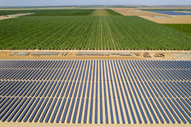
Solar Development Is a Potential Win-Win for the Valley and the State
Solar energy development on formerly irrigated croplands is an attractive option for landowners, and it could help the state meet the mandate for renewable electricity prompted by California’s “100 Percent Clean Energy Act of 2018” (SB 100). This legislation calls for the state to obtain 100 percent of its electricity from renewable energy sources by the year 2045, closely tracking the time horizon for SGMA compliance. Previous work by The Nature Conservancy has shown that the San Joaquin Valley is highly suitable for solar energy development across a broad swath of the valley floor (Wu et al. 2019; Wu et al. 2023) (Figure 9a). And installing solar on former cropland does not pose the same risks to wildlife habitat as in some other sun-soaked areas, such as the state’s undeveloped southeastern deserts.
Roughly 135,000–215,000 acres of solar facilities might be required to create the additional 27 gigawatts (GW) of capacity that some projections suggest would be needed in the valley to meet statewide SB 100 goals. This means that solar would be only part of the equation for repurposing lands that will be fallowed as part of SGMA implementation, especially since some solar development is likely to occur on lands that were retired earlier for other reasons. Yet our discussions with a range of stakeholders suggest that with careful planning and coordination, solar energy could generate several important benefits for the valley—not only replacing some of the lost revenues and jobs from land fallowing, but also helping to manage dust.
Solar-suitable land at high risk for fallowing does not always align with today’s transmission infrastructure

SOURCES: (a) Wu et al. (2023); (b) PPIC estimates, from Escriva-Bou et al. (2023); (c) developed by PPIC using data from the California Energy Commission and the California Independent System Operator.
NOTES: kV is kilovolt; MW is megawatt. Land suitable for solar energy production in panel (a) excludes land with legal restrictions against energy development and administratively protected areas. This includes roughly 3.9 million acres of irrigated cropland and 2.5 million acres of non-irrigated lands. Highlighted acreage in panel (b) is current irrigated cropland that is both suitable for solar and at high or very high risk (>25%) for fallowing under one of several trading scenarios (no trading, basin trading, and/or valley trading); gray area is all other irrigated acreage. The interconnection queue refers to proposed projects that require approval of interconnection conditions or infrastructure investment to ensure interconnection before beginning construction. The 500 kV (red) line in panel (c) delineates high-voltage lines that can transport electricity out of the valley to demand centers elsewhere in the state. Zip codes are colored by the total capacity of all queued projects within them.
Reaping these benefits will require overcoming complex and protracted permitting processes, which create bottlenecks in the project queue (Ayres et al. 2022). And perhaps most importantly, projects must be able to connect to an electrical grid that can ferry electricity out of the valley to other demand centers. But constructing the infrastructure needed for improved interconnectivity is costly and time consuming. Most high-voltage transmission capacity lies on the western side of the San Joaquin Valley, not necessarily near the lands at highest risk of fallowing under SGMA (Figure 9b and 9c). Facilitating reallocation of irrigation water from lands developed for solar to other lands—both locally and even across basins—could help growers keep other lands in production. Transmission planners may also wish to consider opportunities for aligning new investments with high-risk lands. Engaging with GSAs and other local entities can help planners understand where suitable land may become available. There is also growing interest in pursuing more distributed development of solar to primarily serve local activities; this could facilitate more solar where connecting to the grid would be too costly.
Water-Limited Crops Could Keep More Land in Production
In recognition of the looming water scarcity facing valley agriculture, interest is growing in crops that might be both agronomically and economically viable with much less water. This includes both some novel specialty crops that are normally grown in very dry places, like agave (Klinge 2022) or guayule (Bañuelos et al. 2022), as well as cool-season forages and grains like wheat, oats, and barley, which were once a mainstay of valley agriculture. We explored the potential for reintroducing these nimble field crops, which can be grown in California’s rainy season, whether as dryland crops that receive no irrigation or as water-limited crops that receive small amounts of supplemental irrigation.
By modeling winter wheat establishment and forage production across currently irrigated cropland in the San Joaquin Valley, we found that rainfall variability made establishing dryland (non-irrigated) crops a difficult proposition. But eight inches of supplemental irrigation—much less than the 30–50 inches most crops use annually—was sufficient to substantially boost the success and economic viability of water-limited crops across much of the valley floor (Figure 10; Peterson, Pittelkow, and Lundy 2022 and 2023). While not thought of as large revenue generators, these low-input crops can generate high returns per unit of applied water under certain price and cost scenarios (Peterson and Hanak 2022). And as summer-irrigated livestock feed crops like alfalfa decline in acreage, the valley’s large dairy and beef industries may present a source of sustained demand for less thirsty feeds. As Figure 10c shows, dairies operate principally in areas where water-limited cropping may be suitable.
These results reflect what would be possible under typical rainfall conditions, with supplemental irrigation available at the right time and place; in reality, such conditions are likely to be less widespread. That said, production-oriented agriculture is not the only context in which shifts to water-limited crops may be worthwhile. For example, relatively modest amounts of biomass can be grazed by small livestock or leveraged to protect topsoil, reduce dust emissions, and keep lands in operation so they can pivot to more lucrative crops should conditions change. Such lands may also be able to pivot flexibly to groundwater recharge in wet years.
Even so, water-limited crops face uncertainties in both market conditions and production risks (e.g., potential increases in soil salinity with less irrigation, and higher weed pressure with less operating capital for weed management). In consequence, leveraging these benefits at scale will require technical assistance, continued research and development, and incentives. An important component of getting incentives right will be ensuring that GSAs accurately account for the net water use of water-limited winter crops. Many of the benefits of these crops—e.g., improved rainfall capture and infiltration—are difficult to assess with current accounting methods. Early results suggest that water use by these crops may compare favorably to fallow fields, but further research is needed to fully understand their impact on local water budgets. In the meantime, local policies and programs should avoid disincentivizing potentially beneficial land stewardship practices.
Water-limited forage crops are widely feasible in the valley with small amounts of supplemental irrigation
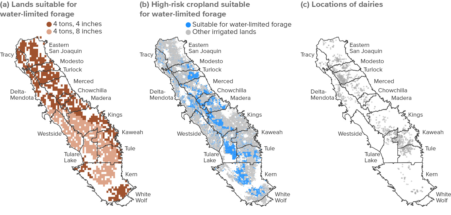
SOURCES: (a) Peterson, Pittelkow, and Lundy (2023); (b) PPIC estimates; (c) California Integrated Water Quality System regulated facilities and the Central Valley Regional Water Control Board. For details, see technical appendix.
NOTES: An area is considered suitable for water-limited forages if it can reliably achieve forage yields of 4 US tons per acre with 4 or 8 inches of supplemental irrigation. Forage yields of 4 tons were estimated to result in sufficient revenue to cover operating costs under some cost/price scenarios (see Peterson and Hanak 2022). Data constraints limit spatial resolution of suitability in panel (a) to areas of approximately 4 square kilometers. Highlighted acreage in panel (b) is current irrigated cropland that is suitable for water-limited forages with 4 or 8 inches of supplemental irrigation and at high or very high risk for fallowing under SGMA (>25%) under no trading, basin trading, or valley trading (see Escriva-Bou et al. 2023); gray area is all other irrigated acreage. Panel (c) illustrates the locations of dairy operations in the valley, which may demand feed from water-limited cropping areas in the future.
Habitat Restoration Could Bring Benefits on Some Fallowed Lands
In addition to being the largest agricultural region in California, the San Joaquin Valley is also a hotspot for endemic and endangered species of special interest to the conservation community (Butterfield, Kelsey, and Hart 2021). SGMA implementation opens the possibility of restoring some habitat that was displaced by agricultural development (Hanak, Peterson, and Hart 2022; Ayres 2021b). In particular, upland habitat restoration, especially in key corridors that connect existing conservation areas, can create high value for conservation with extremely low water requirements. Figure 11 plots the roughly 1.1 million acres of irrigated lands that might have the highest value for upland restoration, given their habitat features and proximity to existing wetland or upland conserved areas (panel a). More than half of this area overlaps with lands at high or very high risk of fallowing under either the no trading scenario (panel b) or valley trading (panel c).
There may also be opportunities for restoring wetland and riparian areas on some fallowed lands—particularly if the future sees more surface water trading across basins. Although these areas could have high conservation value, they would entail less water savings relative to cropland than upland areas because they would be more dependent on reliable water supplies to support ecosystem health.
Opportunities for upland habitat restoration may arise on formerly irrigated cropland
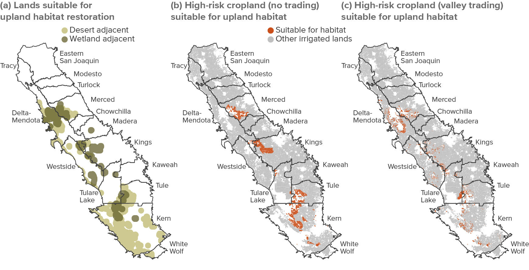
SOURCES: (a) The Nature Conservancy; (b-c) PPIC estimates, from Escriva-Bou et al. (2023). For details, see technical appendix.
NOTES: Panel (a) shows potential upland habitat within a buffer radius of 5 kilometers around existing conservation areas. An area is considered suitable for upland (San Joaquin Desert) habitat if it can host at least one desert species of special concern (kit fox, blunt-nosed lizard, San Joaquin woolly-threads, or kangaroo rat). Highlighted areas in panels (b) and (c) reflect current irrigated cropland that is 1) suitable for habitat and 2) at high or very high risk for fallowing under SGMA (> 25%) with no trading (panel b, 333,000 acres) or valley-wide trading (panel c, 256,000 acres); gray area is all other irrigated acreage. Given some overlap, high-risk suitable land in either scenario totals 521,000 acres.
Despite the growing awareness of the opportunities for habitat as a land use alternative in the valley, restoration on large scales remains a challenge. One major issue is the high cost of projects—both for establishment and ongoing management of restored sites. Finding ways to bring costs down will be essential to re-establishing habitat across large acreages, given the limited opportunities for directly generating revenues on these lands. Other issues include limited institutional capacity to manage these lands, the need for legal assurances to protect neighboring landholders from endangered species liabilities, complex permitting requirements, the limited availability (and high cost) of native seeds, and the high degree of regional coordination needed to ensure connectivity among conservation areas.
New Recharge Basins Could Bring Multiple Benefits
Active groundwater recharge has been practiced in parts of the valley for decades, and most GSPs emphasize expanding recharge to bring their basins into balance (Hanak et al. 2020). Some recharge occurs by channeling more water into unlined canals or through “in-lieu” methods, where farmers are incentivized to use more surface water (and less groundwater) in wet years. But dedicated recharge basins have also been popular—especially in Kern and some eastside water districts that are set up to capture and recharge large volumes of water in high-flow years (Hanak et al. 2018a). These basins—typically designed as large earthen ponds that temporarily fill with water—cover about 50,000 acres valley-wide (Partner Engineering and Science 2019).
As GSAs and individual farmers plan for recharge expansion, one big question is how much effort will go towards creating new dedicated basins—which entails substantial upfront costs in land and labor—versus methods that temporarily repurpose other lands. In particular, there is growing interest in spreading water directly on active cropland in suitable areas (Peterson and Bardeen 2023). This approach might be especially cost-effective for maximizing recharge in very wet years, such as 2023; dedicated basins that sit empty in all but the wettest times are less likely to be good investments.
Another consideration is whether dedicated recharge basins can provide additional benefits, opening up possibilities of bringing in other funding. As one example, the new Okieville recharge basin in the Kaweah basin—a 20-acre project—will raise groundwater levels beneath this groundwater-dependent low-income community, and potentially improve water quality as well (Cahill 2023). And as the more than 7,000 acres of recharge ponds of the Kern Water Bank (by far the valley’s largest existing recharge project) demonstrate, leaving more natural features intact—rather than building engineered earthen ponds—can allow these areas to serve as high-quality intermittent wetland habitat (Hanak et al. 2019, chapter 4). The environmental community has shown interest in expanding these kinds of multi-benefit recharge projects (Bourque et al. 2019; Schiller 2020). That said, lands that are managed with both species conservation and intermittent recharge in mind will need protective legal structures in the event that endangered species reestablish themselves in the area.
In light of feasibility and cost considerations, we expect that new recharge basins might occupy another 20,000 to 40,000 acres of land in the valley—not large relative to the total acreage likely to be fallowed, but enough to make a difference locally, especially if designed to reap multiple benefits.
New Development Could Bring New Revenues While Saving Water
The eight San Joaquin Valley counties are home to more than 4.3 million residents, and the valley has long been one of the fastest-growing regions of California. Population grew by about 1 million between 2000 and 2020, and until recently state demographers anticipated continued rapid growth, with roughly 800,000 more residents expected by 2040 (Figure 12). The recent demographic shifts—which saw California’s population fall for the first time on record in both 2021 and 2022—have been less pronounced in the valley, where population fell slightly in 2022. These unanticipated shifts make forecasting very uncertain. The state’s interim forecasts from mid–July 2023 project less than half as much growth in the valley (and almost no growth for California) by 2040, but a full set of new projections is not expected until summer 2024. Here, we use the projections in Figure 12 to explore the implications of population growth as a water-saving land use, recognizing that the future may see slower growth.
In this heavily agricultural region, urban development often entails the conversion of farmland around existing communities (Unger and Thompson 2013). For growers and local governments alike, this conversion can be lucrative. One much-debated question is whether it can also reduce total water use and contribute to balancing basin supplies with demand (Ayres et al. 2021a).
The valley could continue to experience rapid population growth as SGMA is implemented
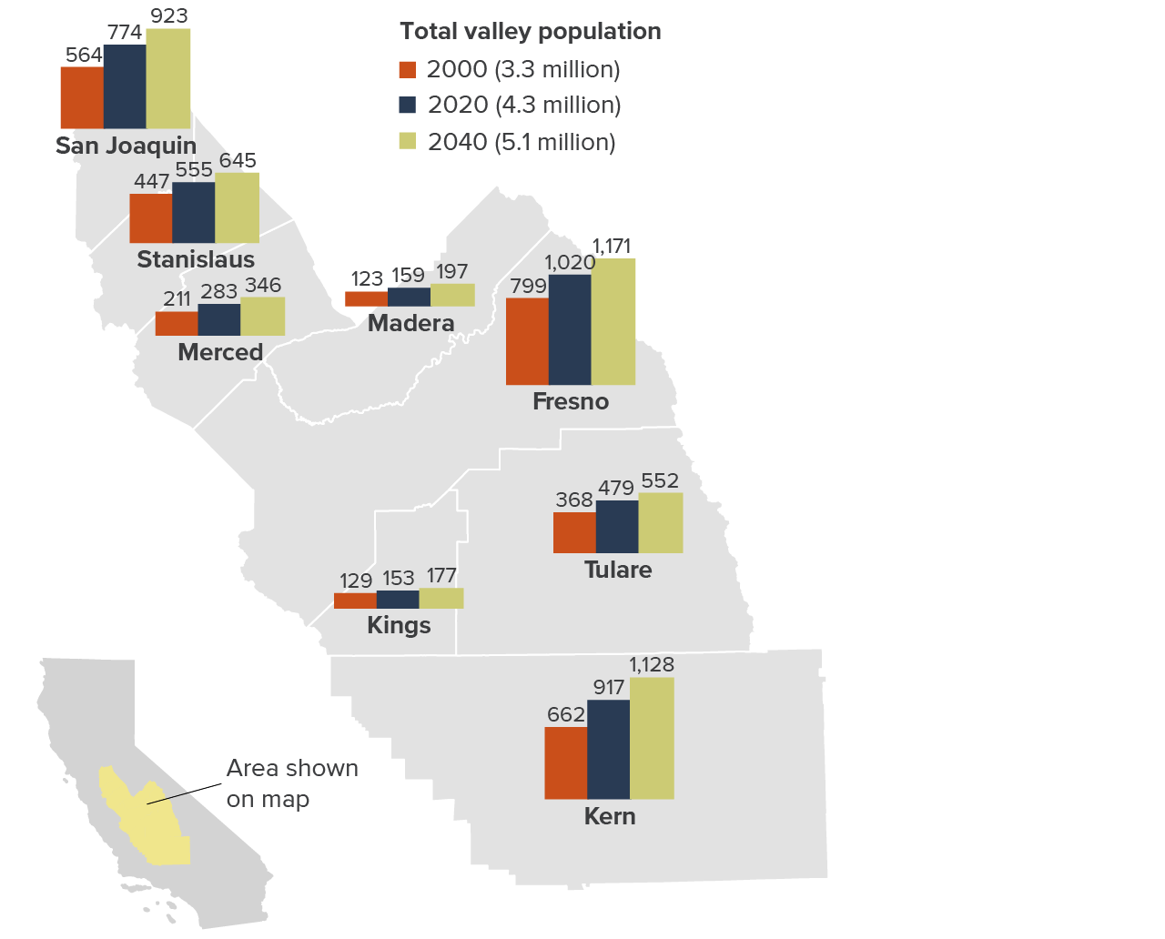
SOURCE: California Department of Finance (downloaded July 6, 2023).
NOTES: Numbers shown for counties are in thousands. As described in the text, the state is currently in the process of updating population forecasts, and it is likely that the full projections to be released in mid–2024 will show slower growth.
Using customer-level water use data from four valley communities, we found that new residential development may indeed require substantially less water per acre than irrigated cropland. In the hotter, thirstier regions like Kern, urban areas use about one-fifth as much as cropland for outdoor watering; this ratio is even lower in some areas further north. Outdoor water savings occur mainly because an acre of urban or suburban land has considerably more buildings and pavement—and less irrigable area—than an acre of cropland. Expected gains in water use efficiency could further reduce per-acre water use on residential lands. Of course, water utilities also need to provide supplies for indoor use in these communities. But in contrast to landscape irrigation, almost all indoor water returns to the water system as treated wastewater and becomes available for recharge or use by others within the system. On balance, if growth occurs at the pace projected in Figure 12, new development could cover some 50,000 acres of land. If all of this development occurred on current cropland—which is unlikely—it would provide annual water savings of roughly 175,000 acre-feet. While this is not a major land use opportunity, it can generate new revenues while helping to bring groundwater basins into balance. Careful land use planning could ensure that land most suitable for recharge, for example, is not developed without some consideration of the tradeoffs first.
A Landscape of Opportunity
Taken together, the picture that emerges from this review is one of opportunity in the face of a major challenge: much of the cropland in the San Joaquin Valley is suitable for at least one of three major alternative uses (Figure 13). Roughly 1,500,000 acres of solar, 1,300,000 acres of water-limited forage production, and 525,000 acres of habitat are suitable on high-risk lands alone. Nearly 330,000 high-risk acres would be suitable for any of the three options. In every basin, land suitable for these alternatives exceeds our upper bound estimates for land fallowing—which, it bears reminding, pessimistically assume that all overdraft will be addressed through demand management, without new supplies. These numbers indicate room for flexibility in project siting. This is good news, considering that the benefits of solar energy, water-limited cropping, and habitat restoration are greater across larger, consolidated land areas—whether for reasons of economies of scale or the habitat requirements of species of concern (see note 42).
These numbers also suggests that with the right incentives, and with broad-based, cooperative planning and implementation, land use transitions could occur in ways that would allow agriculture to continue to thrive while minimizing the downsides of fallowing and creating other benefits. We next explore how the region might overcome the hurdles to the planning and implementation of a successful transition.
The valley’s farmland would support multiple low-water alternative uses
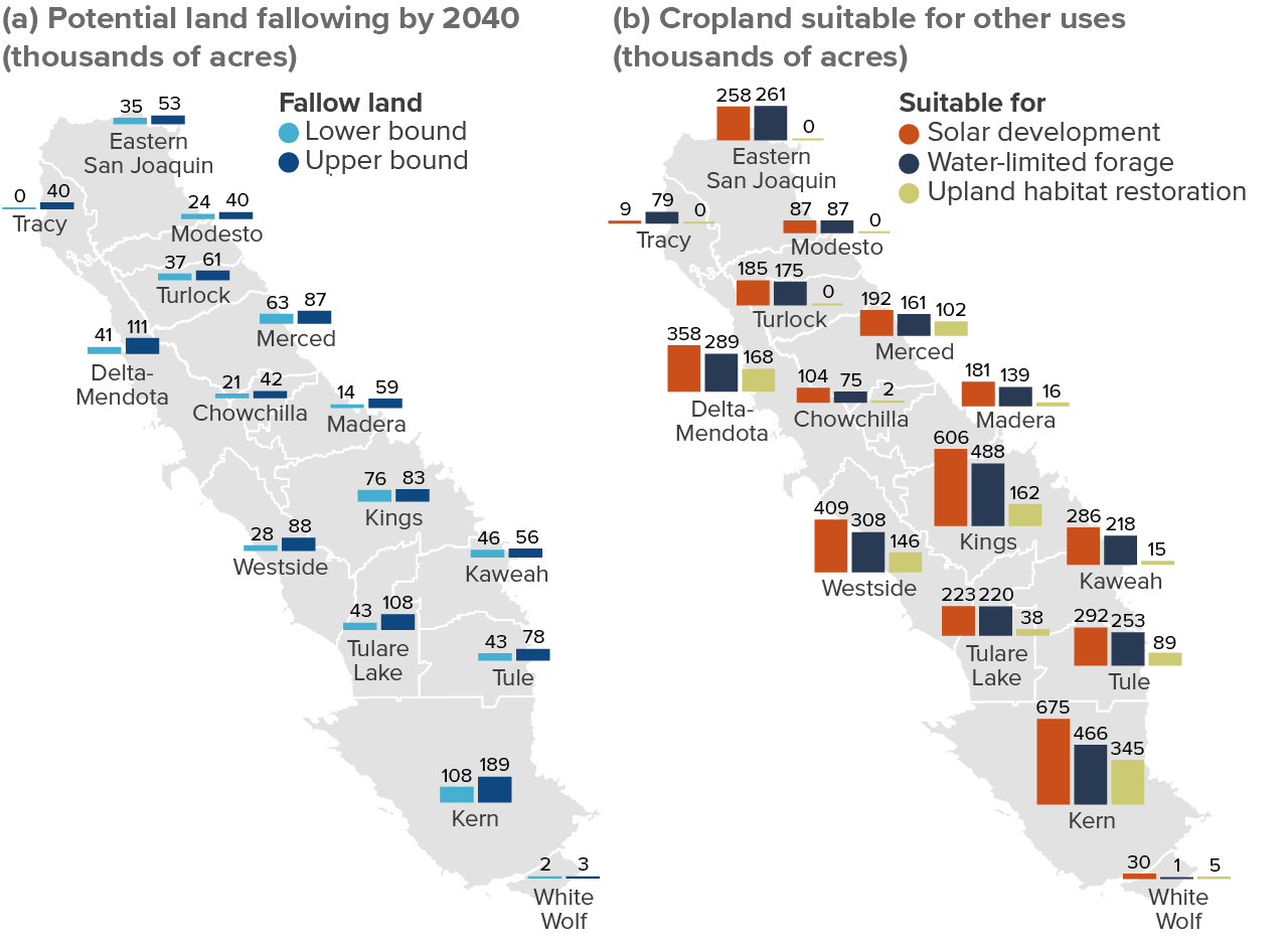
SOURCE: PPIC estimates. See notes to Figure 3 for land fallowing (panel a) and Figures 9–11 for the alternative land uses (panel b).
NOTES: Panel (a) shows the range of fallowing under the different trading scenarios if all overdraft is addressed by reducing pumping; lower and upper bound estimates may come from different scenarios in different basins. Panel (b) shows the amount of currently cropped acreage that would be suitable for the three land uses. Given data limitations, the map does not show acreage suitable for two other land uses discussed in the text—recharge basins and water-saving residential development.
Getting to Sustainable Water and Land Use
Meeting the water scarcity challenges now facing the San Joaquin Valley—and effectively managing the transition of thousands of acres of farmland to other uses without exacerbating air pollution—will require bold and sustained actions on multiple fronts: strong coordination across basins and sectors, strategic infrastructure investments, robust water trading rules, focused research and development, and alignment of various regulatory, fiscal, and funding programs with the goals of attaining groundwater sustainability. While the primary responsibility for developing and implementing effective approaches lies at the local level—in the hands of GSAs, other local authorities, water users, landowners, and various other stakeholders—state and federal agencies can play vital supportive roles. Here, we review some of the key action areas and highlight how the different parties can help.
Strengthen Coordination
Cooperative approaches will be critical to implementing the most beneficial SGMA strategies and avoiding haphazard land fallowing and its attendant risks. Although SGMA has spurred many new partnerships, much of the work to date has focused on planning within the jurisdictions of individual GSAs rather than across entire basins or the region as a whole. Yet without broader coordination, GSAs can miss opportunities to take advantage of actions that require partnerships across jurisdictional lines, including water trading, new supply projects, and some types of land repurposing. Coordination across sectors will also be key for encouraging beneficial land transitions in areas such as solar energy, habitat restoration, recharge, or new residential development. Local and regional entities will need to take the lead on this work, but the state can incentivize it (as discussed below).
- Build basin-wide and regional approaches. Now that SGMA implementation is in full swing, GSAs and their members should seek to take the broader view, bringing together various parties both within and across basins to take advantage of opportunities for cooperation. Two nascent regional efforts—the San Joaquin Valley Collaborative Water Action Plan (SJVCAP) and the Water Blueprint for the San Joaquin Valley—could serve as a starting point. The state’s new Multibenefit Land Repurposing Program (described below) is another promising vehicle for forging diverse partnerships. Who: GSAs and their members, growers, local governments, community groups, tribes, NGOs, and other local stakeholders.
- Build stronger linkages across sectors. Coordination between GSAs and the local land use authorities—especially counties—will be critical for many decisions around farmland repurposing. Energy and wildlife agencies need to be part of the mix for making strategic decisions on solar development and habitat restoration, with input from local agencies about how demand management efforts may drive fallowing. While these relationships are already strong in some places, there is room for more coordination. Taking a broader, regional view will also yield dividends. Who: GSAs and their members, county land use authorities, and energy and wildlife agencies and managers.
Make Strategic Water and Energy Infrastructure Investments
Improving the region’s capacity to capture and store additional water—and to move water to the places where it is most needed—will likely require additional investments in water infrastructure. And to facilitate solar energy investments—an opportunity for valley farmland repurposing that is also key to meeting the state’s clean energy goals—upgrades to the power grid are needed. Both sectors will need to consider how they might best support workforce development in communities that risk losing agricultural jobs and take a holistic view of the best opportunities for capacity expansion to bring the broadest benefits.
- Invest in water infrastructure. While there may be some scope for cost-effective expansion of surface storage, groundwater recharge offers the most opportunities for storing water at a price that will keep water affordable for valley growers. Right now, conveyance can be a limiting factor in getting water to the best places for recharge—and to the fields where it will generate the most revenues and jobs. Ongoing subsidence is making things worse. Making headway will require regional analysis of the most important bottlenecks, and development of a shared investment strategy. Who: local and regional water agencies (GSAs, irrigation districts), California Department of Water Resources, US Bureau of Reclamation.
- Invest in energy transmission. Planning for and investing in power grid expansion is a complex, time-consuming process, and it is widely recognized that accelerated action is now needed (Ayres et al. 2022). Developing and rolling out the grid of the future will require unprecedented cooperation among the state’s energy planning and regulatory agencies, utilities, energy developers, and local land use authorities. Energy agencies have begun this coordination, a promising start. A new transmission plan foresees nearly $8 billion in investments to support the electric grid, but the focus is mainly on Southern California, not the valley. State water agencies (especially DWR) may also provide helpful insights in this process. Who: California Energy Commission, California Public Utilities Commission, California Independent System Operator, Department of Water Resources, electric utilities and developers, county land use agencies.
Promote Effective and Responsible Water Trading
Water trading can dramatically reduce the regional economic costs of getting to sustainability in the valley and can facilitate more strategic decisions about which lands to repurpose to other uses. Trading also works well in conjunction with a key supply enhancement strategy, groundwater banking, where parties store water in aquifers for later use. Fostering transparent, readily accessible water markets will be essential, since smaller growers can also benefit from the flexibility that trading provides. And while our analysis suggests that significant unintended impacts from trading are not likely—whether for small farms, rural drinking water wells, or community exposure to dust—guardrails must be in place to avoid such impacts on other water users and the environment. Support for communities and sectors impacted economically by water trading also merits consideration.
- Establish robust local groundwater markets. GSAs have the authority to establish groundwater markets, but they first need to develop some of the basics: strong groundwater accounting and monitoring systems, and allocations of how much users can pump. The next step is establishing transparent trading rules and platforms, which guide where and how much water can be traded, with guardrails to avoid significant undesirable results. This may include establishing “no-buy” zones for groundwater in sensitive areas (e.g., where pumping more would aggravate subsidence) and determining where mitigation is a viable alternative to pumping less (e.g., to maintain drinking water access for affected wells). Groundwater trading limits may need to be more restrictive in the transitional years, while basins are still in overdraft. Who: GSAs.
- Improve the flexibility of surface water markets. Surface water trading is already common, and guardrails are in place to avoid significant undesirable results to other water users and the environment. But the rules and procedures are often too restrictive—preventing trading that would provide significant benefit both within and across basins. Who: local water districts and agencies, Central Valley Project, State Water Project.
- Consider support for communities and sectors experiencing economic impacts from trading. Because trading moves water to crops that generate higher economic returns, it can have spillover effects on crops that are less profitable. In the valley, alfalfa and some other feed crops are likely to decline, raising costs for the dairy and beef sectors. Especially when these impacts are concentrated in certain communities, transitional financial support may be warranted, either as part of the trading agreement (paid by the water buyer) or as part of a broader package of policy support for SGMA implementation. Who: Trading parties, GSAs, water districts and agencies, state and federal governments.
Expand the Knowledge Base on Water-Limited Crop Alternatives
Water-limited crop alternatives could occupy significant acreage that would otherwise be fallowed, providing both economic and environmental benefits. While winter crops are familiar to many California farmers—whether for dust mitigation, soil protection, or harvestable products—growing them under water-limited conditions in the San Joaquin Valley will require further research, development, and technical (and potentially also financial) assistance. Some of these research questions also apply to other land use alternatives, especially habitat.
- Refine cropping systems and test management approaches for the valley. Trialing new crop portfolios and developing appropriate varieties will be necessary not only for water-limited crops grown with a marketing objective, but also for water-limited vegetation or cover crops established for dust mitigation or habitat purposes.
- Analyze market factors. Understanding potential consumer demand for winter forages and more novel low-water crops can help guide investment decisions.
- Improve understanding of net water use. Our preliminary work suggests that water-limited cropping systems may consume water at similar rates to bare fallow fields (Peterson, Pittelkow, and Lundy 2022). Improving understanding of this issue is key for correctly structuring water accounting methods—and incentivizing growers to plant these crops. Answering similar questions for various types of habitat, cover crops, and wildlife-friendly recharge facilities could also support project planning.
- Assess other potential constraints. Since these systems rely on much less irrigation than the winter crops grown today, it is also important to assess the potential impact of other interacting factors such as soil salinization and perennial weed pressure, which could affect cost and long-term sustainability.
Who: Universities, the cooperative extension services, and technical assistance providers such as Resource Conservation Districts (RCDs), USDA’s Natural Resources Conservation Service (NRCS), and NGOs.
Align Regulatory and Fiscal Incentives
In numerous respects, the regulatory and fiscal landscape is not well aligned with SGMA goals—particularly when it comes to stewardship of transitioning farmlands. Many rules and programs were created well before SGMA was enacted, and before the recognition that significant irrigated acreage may need to be retired or repurposed to fulfill SGMA’s sustainability directives. Here are some of the key issues that merit attention:
- Allow growers to maintain access to water rights on transitioning lands. For many growers, having the option to continue benefitting from the water associated with their lands would facilitate the alignment of fallowing decisions with broader land repurposing goals. This water is an asset that could help defray the costs of reducing irrigated acreage—enabling growers to keep other lands in production or get compensated for foregoing their own use. One example is allowing growers in areas with high subsidence risk to sell their groundwater allocations to parties in lower-risk areas, thus reducing pumping pressures in the seller’s vicinity. Who: GSAs (for groundwater), local water districts and agencies (for surface water), state and federal agencies (for State Water Project and Central Valley Project water, respectively).
- Establish consistent rules for managing dust on fallowed lands. At present, the regional air district considers fallowing to be an acceptable method for managing dust in farming areas—in recognition of the fact that agricultural activity also generates dust. But when lands are fallowed as part of a water trade, they must consider dust impacts as part of their impact assessment under the California Environmental Quality Act (CEQA). To protect the region’s residents from harmful dust, while also facilitating water trading that could protect the regional economy, consistent guidance on how to manage dust on fallowed lands is needed. The regional air district should continue to engage partners as it updates its conservation management practice rules regarding fallowed land. Who: the regional air district, in partnership with growers.
- Provide legal assurances for habitat conversions. When landowners devote some lands to habitat restoration, both they and their neighbors risk violating state and federal endangered species rules if listed species then become present on active farmland. Safe harbor agreements and similar legal assurances—such as the state’s voluntary local programs (VLPs)—can provide legal protections for participating parties, and help encourage land repurposing, but they are rarely used in this region (Hanak et al. 2019). Who: California Department of Fish and Wildlife, US Fish and Wildlife Service, landowners.
- Reevaluate CEQA requirements for protecting prime farmland. When prime farmland is converted to alternative uses, CEQA rules require mitigating for that action by protecting other farmland from development. This rule was established to avoid losing farmland, but it no longer makes sense in areas where some lands will need to find new uses because of the lack of water. Faster and more flexible reclassification of such lands would facilitate repurposing. Changing this rule may require legislation. Who: California Legislature.
- Relax CEQA requirements for implementing GSPs. Although groundwater sustainability plans themselves were exempt from CEQA, GSA actions to implement those plans are not. This raises the potential for lengthy delays and costs—even for things as basic as encouraging strategic, rather than haphazard, land fallowing to manage demand. After several failed legislative attempts, an executive order issued in 2022 (EO N-7-22) provided CEQA exemptions for GSP projects that would help manage drought. Legislative action to make this exemption permanent would support sustainable water and land management. Who: California Legislature.
- Adapt Williamson Act rules to accommodate beneficial farmland transitions. Since the mid-1960s, the widely used Williamson Act program has reduced property taxes for lands kept in agricultural uses or open space (Rosser 2022). Local governments (mainly counties) set rules on what uses qualify. For farms that lose water access under SGMA, the penalties for withdrawing from the program could make it difficult to transition to other uses. While water-limited farming and grazing will likely remain compatible, counties should clarify that other uses—such as groundwater recharge, habitat restoration, and cover cropping on fallowed lands—qualify as open space. Some counties have also permitted certain types of solar, for instance when installations integrate grazing under panels (Ayres et al. 2022). They could also authorize no-fee contract cancellations where lands lose water. Statewide legislation could help provide consistency and relieve local government of the local amendment process. Who: county governments, California Legislature.
- Facilitate permitting for water and energy projects. Groundwater recharge, other water infrastructure, and energy infrastructure projects all face added costs and delays because of the complexities of the environmental permitting process. Meeting water sustainability and clean energy goals will require striking a better balance. Some recent reforms to permitting—including budget trailer bills to facilitate recharge and speed judicial review of CEQA lawsuits—may help, but there is likely additional room for simplifying the review process. Who: state and federal agencies, the California Legislature.
Provide Financial Incentives
Finally, funding will be a key ingredient in ensuring smooth transitions. Incentive payments and cost sharing with GSAs and landowners can encourage coordination, help prevent negative impacts on fallowed lands (e.g., dust), support infrastructure, and promote investments in alternative land uses that need further testing (e.g., water-limited cropping) or that won’t pay for themselves (e.g., habitat). Funding for research and development and technical support to help with implementation is also needed. While there is some potential for local entities to generate funds for these purposes, state and federal programs will be critical. Here are some examples of local, state, and federal efforts that merit sustained support:
Local funding
SGMA authorizes GSAs to assess fees to cover the costs of plan implementation, and some GSAs have adopted pumping fees or land assessments for this purpose. Mitigation fees from land development and infrastructure projects can also support habitat restoration.
- Funding GSA projects and actions. Early examples include payments to incentivize strategic land fallowing (e.g., in the Tule basin), mitigation programs for drinking water wells affected by pumping (several basins), and investments in local recharge and other water infrastructure. Getting these funds approved by local pumpers can be challenging, however, especially since groundwater users have not been accustomed to paying for water services. In Madera, the county GSA is facing legal challenges to fees that a majority of landowners approved (Vad 2022).
- Funding habitat restoration. Mitigation requirements for various types of land development (including solar installations) are already used in the valley to acquire habitat and may be particularly helpful for managing lands to support endangered species.
State funding
Both general obligation bonds and General Fund dollars have funded programs that either directly or indirectly support meeting SGMA goals.
- Support for SGMA planning and implementation. State funding for local planning work has been essential in the early stages of SGMA implementation, and more recently, grants have become available to support local investments—and particularly recharge projects. Further support for capacity building in GSAs and other entities, such as RCDs, presents an opportunity for state dollars to go far.
- Support for farmland repurposing. Two new programs are specifically geared to supporting land transitions. Since 2022, the Department of Conservation’s Multibenefit Land Repurposing Program has awarded $90 million in block grants to GSAs and partner organizations in eleven critically overdrafted basins, including eight in the valley. And in 2023, the Department of Water Resources launched the LandFlex program, with $25 million for payments to growers for cutting back pumping in areas that can protect drinking water wells. Learning from the successes and challenges of these early efforts can inform future support for repurposing.
- Support for habitat restoration. Although not directly aimed at SGMA, state grants for habitat conservation, such as those funded by the Wildlife Conservation Board, can support land acquisition and easements where conservation efforts promise large ecological benefits—and in the case of upland habitat, where water requirements are low.
- Support for water and energy infrastructure and planning. Water infrastructure investments include items such as matching funds for repairing damaged water conveyance. And although ratepayers fund energy transmission, state planning support can facilitate timely and suitable investments.
Federal funding
Some core federal programs support activities that are relevant for meeting SGMA goals, and the recent Bipartisan Infrastructure Law and Inflation Reduction Act make additional funds available.
- Farm Bill programs for resource management. Various USDA programs run through NRCS and the Farm Services Agency (FSA) can help with an array of land stewardship actions, and considerable funds are available for the valley (Jezdimirovic and Hanak 2019). NRCS partners with the regional air board on supporting dust management (Ayres, Kwon, and Collins 2022), and there is potential to support water-limited cropping and other low-water management options like grazing. California could also develop a partnership with USDA to support stewardship of fallowed lands through the Conservation Reserve Enhancement Program (CREP), as some other western states have done (Mount et al. 2016; Booth 2023). FSA’s new CLEAR30 pilot program can also support long-term stewardship of some lands.
- Other federal programs for water and energy infrastructure. The US Bureau of Reclamation, the Army Corps of Engineers, and the US Environmental Protection Agency all support water management and infrastructure in California, and the US Department of Energy has funds to support energy infrastructure. At a time when substantial federal funds are available, the valley has an opportunity to garner significant support—especially if it can speak with one voice.
Conclusion
The San Joaquin Valley is an agricultural powerhouse and home to millions of California residents, but it is facing an uncertain future. Declining water supplies driven by SGMA (and compounded by climate change and new environmental flow requirements) will likely lead to widespread land fallowing, job losses, public health risks, and reduced economic activity in a region that depends heavily on agricultural production. SGMA, despite near-term growing pains, will ultimately help ensure the long-term sustainability of valley agriculture by enhancing groundwater availability. And all signs suggest the region can meet this challenge. The valley has proven itself to be resilient over the years: time and again, growers and other residents have weathered dramatic transitions and found a path forward—often by embracing innovation.
There is nothing to suggest that this transition will be any different. Rising to the challenge will demand unprecedented local action and the forging of new regional partnerships. Early signs indicate that despite the challenges and conflicts, SGMA is starting to encourage new forms of collaboration. As implementation gains steam, now is the ideal time for bold pilot projects and regional coordination efforts that can set the stage for wider actions. In two decades, the valley may look very different, with a mosaic of solar farms, managed habitat areas, recharge basins, and productive farmland forming a robust, interconnected landscape. These differences will reflect a region that confronted challenges head-on, came together to find broad-based solutions, and made them happen—for the benefit of all the valley’s residents. California as a whole will also benefit from the valley’s success in managing this transition. And communities across the West stand to gain from the valley’s experience as they grapple with their own water scarcity and land management challenges.
Topics
Drought Safe Drinking Water San Joaquin Valley Water Supply Water, Land & Air